Approximate Location Map
Large Map »
Latitude: 52.2458 / 52°14'44"N
Longitude: 0.7157 / 0°42'56"E
OS Eastings: 585497
OS Northings: 264318
OS Grid: TL854643
Mapcode National: GBR QF0.1S0
Mapcode Global: VHKD4.CT78
Plus Code: 9F426PW8+87
Entry Name: 10, Angel Hill
Listing Date: 7 August 1952
Grade: II
Source: Historic England
Source ID: 1141159
English Heritage Legacy ID: 466628
ID on this website: 101141159
Location: Bury St Edmunds, West Suffolk, IP33
County: Suffolk
District: West Suffolk
Civil Parish: Bury St Edmunds
Built-Up Area: Bury St Edmunds
Traditional County: Suffolk
Lieutenancy Area (Ceremonial County): Suffolk
Church of England Parish: Bury St Edmunds St John the Evangelist
Church of England Diocese: St.Edmundsbury and Ipswich
Tagged with: Building
BURY ST EDMUNDS
TL8564SW ANGEL HILL
639-1/14/167 (North side)
07/08/52 No.10
GV II
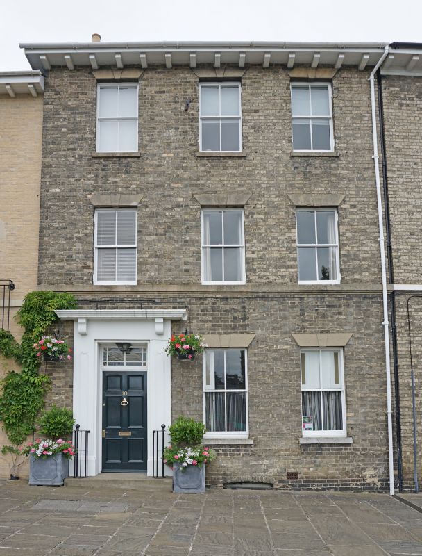
House. Late C16/early C17 core, early C19 exterior. White
brick and slates; mutule eaves soffit; timber-framed fragments
inside.
EXTERIOR: 3 storeys and cellar. 3 window range: sashes with
single vertical glazing-bars in plain reveals with cement flat
arches and raised keystones. A cement band runs at 1st storey
window-sill level. A C19 door surround has panelled pilasters
and a small cornice on stub brackets. A later rear extension
has 2 flat-headed dormers in the rear slope of the roof with
2-light 4-paned casement windows.
INTERIOR: one exposed chamfered main beam of c1600 in the
front range. A good early C19 stair, originally free-standing,
but now against the west wall, has slender turned balusters on
each side and a plain ramped handrail. A similar flight to the
2nd storey. The principal 1st storey room has a moulded
plaster cornice and casing to the main beam. During part of
the C19 this house was used as a girls' boarding school. One
bay to the left of the entrance door was demolished after
being severely damaged by a fire which destroyed the adjoining
house to the west in 1912.
Listing NGR: TL8549764318
External links are from the relevant listing authority and, where applicable, Wikidata. Wikidata IDs may be related buildings as well as this specific building. If you want to add or update a link, you will need to do so by editing the Wikidata entry.


Other nearby listed buildings
