Approximate Location Map
Large Map »
Latitude: 49.9609 / 49°57'39"N
Longitude: -6.2818 / 6°16'54"W
OS Eastings: 93024
OS Northings: 15541
OS Grid: SV930155
Mapcode National: GBR BXWS.FFG
Mapcode Global: VGYBZ.27FS
Plus Code: 8CXMXP69+97
Entry Name: K6 Telephone Kiosk
Listing Date: 14 December 1992
Grade: II
Source: Historic England
Source ID: 1141206
English Heritage Legacy ID: 62463
ID on this website: 101141206
Location: Higher Town, Isles of Scilly, Cornwall, TR25
County: Isles of Scilly
Civil Parish: St. Martin's
Lieutenancy Area (Ceremonial County): Cornwall
Church of England Parish: Isles of Scilly
Church of England Diocese: Truro
Tagged with: K6 telephone box
ST. MARTIN'S
SV9lNW HIGHER TOWN
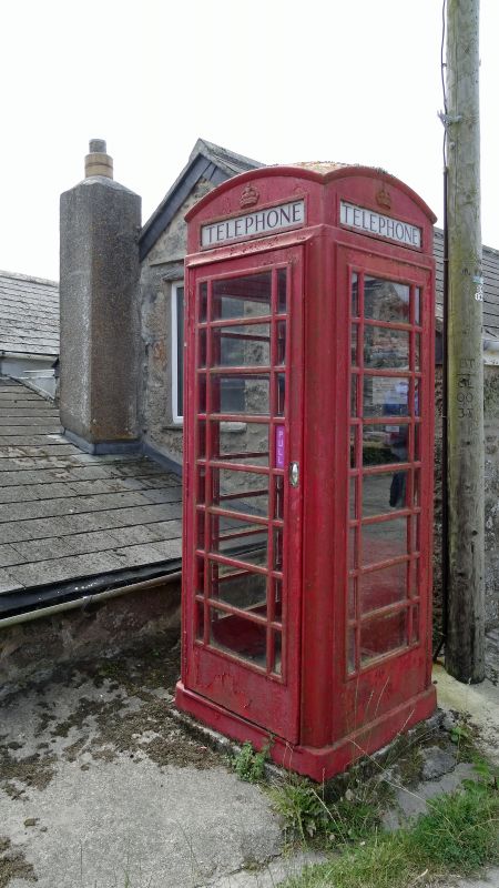
1358-0/2/24 K6 Telephone Kiosk
GV II
Type K6 telephone kiosk. Designed 1935 by Sir Giles Gilbert
Scott. Made by various contractors. Cast iron. Square kiosk
with domed roof. Unperforated crowns to top panels and margin
glazing to windows and door.
Listing NGR: SV9302315540
External links are from the relevant listing authority and, where applicable, Wikidata. Wikidata IDs may be related buildings as well as this specific building. If you want to add or update a link, you will need to do so by editing the Wikidata entry.


Other nearby listed buildings
