Approximate Location Map
Large Map »
Latitude: 50.1869 / 50°11'12"N
Longitude: -5.1744 / 5°10'27"W
OS Eastings: 173496
OS Northings: 36697
OS Grid: SW734366
Mapcode National: GBR Z6.4CX8
Mapcode Global: FRA 081J.HZ8
Plus Code: 9C2P5RPG+Q7
Entry Name: Guide Post at SW735366
Listing Date: 17 June 1988
Grade: II
Source: Historic England
Source ID: 1142030
English Heritage Legacy ID: 66274
ID on this website: 101142030
Location: Stithians, Cornwall, TR3
County: Cornwall
Civil Parish: Stithians
Built-Up Area: Stithians
Traditional County: Cornwall
Lieutenancy Area (Ceremonial County): Cornwall
Church of England Parish: Stithians
Church of England Diocese: Truro
Tagged with: Fingerpost
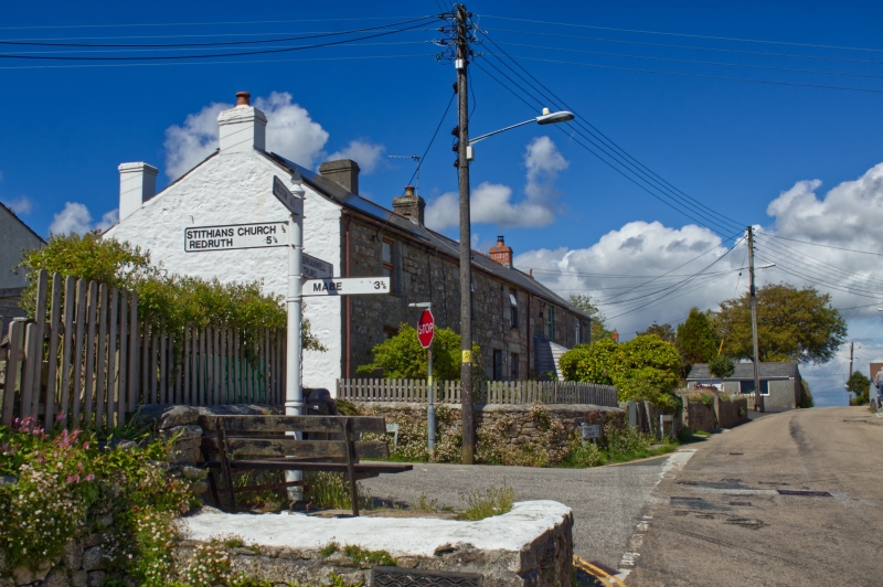
SW 73 NW STITHIANS STITHIANS
2/289 Guide post at SW735366
-
II
Guide post. Circa early C20. Cast iron. Round-on-plan post carrying 3 adjustable pointers surmounted by a spike-head finial. The pointers have integral quadrant brackets, slightly rounded ends and embossed inscriptions.
Left hand pointer:
HELSTON 8½
Middle pointer: MABE 3½
Right-hand pointer: STITHIANS CHURCH ½
REDRUTH 5¼
Listing NGR: SW7349636696
External links are from the relevant listing authority and, where applicable, Wikidata. Wikidata IDs may be related buildings as well as this specific building. If you want to add or update a link, you will need to do so by editing the Wikidata entry.


Other nearby listed buildings
