Approximate Location Map
Large Map »
Latitude: 50.26 / 50°15'36"N
Longitude: -5.2884 / 5°17'18"W
OS Eastings: 165716
OS Northings: 45180
OS Grid: SW657451
Mapcode National: GBR FWBZ.SHC
Mapcode Global: VH12B.9Q3J
Plus Code: 9C2P7P66+2J
Entry Name: Portreath Incline (Raised Lower Section Only)
Listing Date: 12 September 1989
Grade: II
Source: Historic England
Source ID: 1142580
English Heritage Legacy ID: 66784
ID on this website: 101142580
Location: Portreath, Cornwall, TR16
County: Cornwall
Civil Parish: Portreath
Built-Up Area: Portreath
Traditional County: Cornwall
Lieutenancy Area (Ceremonial County): Cornwall
Church of England Parish: Saint Illogan
Church of England Diocese: Truro
Tagged with: Architectural structure
PORTREATH
SW 64 NE
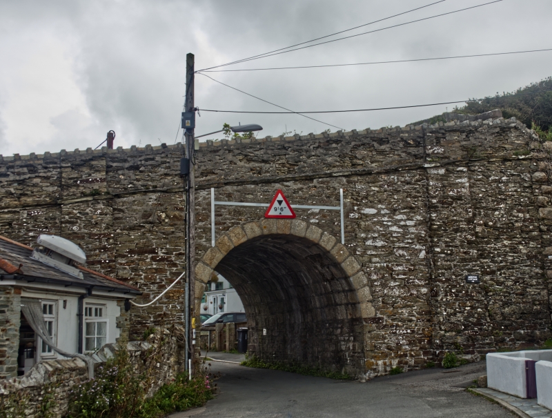
1/228 Portreath Incline
(raised lower section only)
GV II
Part of tramroad incline. 1809, forming the final descent of a tramroad running
from Carn Brea mining area to Portreath Harbour. Retaining walls of coursed
granite and uncoursed killas rubble with granite dressings. North-south axis
approx. 200 metres long, crossing a public road by a semicircular bridge which
has granite voussoirs, shallow battered buttresses, a simple band and a parapet
with brick coping, and slightly constricted near the bottom where it crosses a
stream by a smaller but similar bridge. History: one of the few surviving built
structures of the horse-drawn tramway by which the mine engines were supplied
with fuel before the introduction of steam-powered locomotives; a prominent
feature of the landscape in Portreath. Reference: Michael Tangye Portreath
(1968).
Listing NGR: SW6571645180
External links are from the relevant listing authority and, where applicable, Wikidata. Wikidata IDs may be related buildings as well as this specific building. If you want to add or update a link, you will need to do so by editing the Wikidata entry.


Other nearby listed buildings
