Latitude: 50.1175 / 50°7'2"N
Longitude: -5.5355 / 5°32'7"W
OS Eastings: 147356
OS Northings: 30144
OS Grid: SW473301
Mapcode National: GBR DXQC.M6X
Mapcode Global: VH12Z.09GS
Plus Code: 9C2P4F87+XR
Entry Name: Crownley
Listing Date: 29 July 1950
Grade: II
Source: Historic England
Source ID: 1143149
English Heritage Legacy ID: 69443
ID on this website: 101143149
Location: Penzance, Cornwall, TR18
County: Cornwall
Civil Parish: Penzance
Built-Up Area: Penzance
Traditional County: Cornwall
Lieutenancy Area (Ceremonial County): Cornwall
Church of England Parish: Penzance St Mary the Virgin with St Paul
Church of England Diocese: Truro
Tagged with: Building
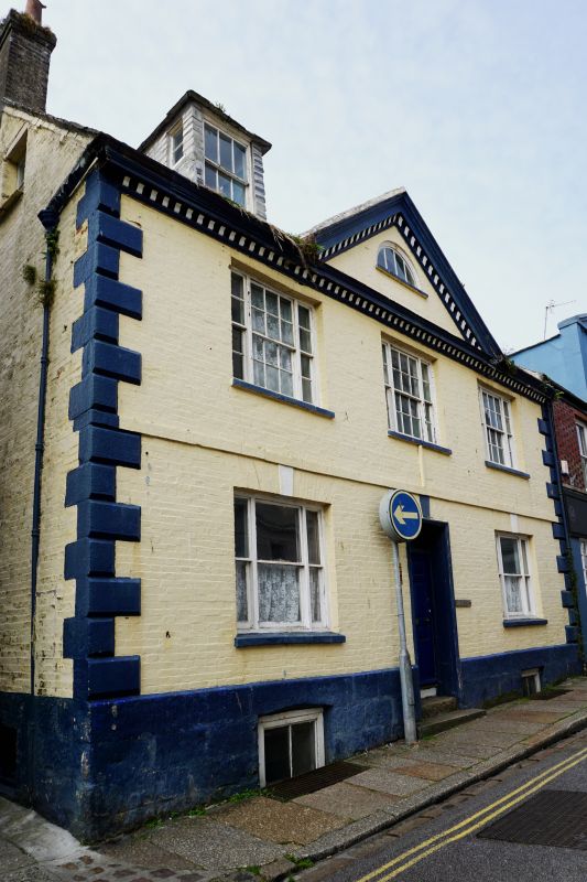
1.
1498 PENZANCE
CHAPEL STREET
(South West Side)
----------------
No 15
(Crownley)
SW 4730 5/22 29.7.50.
II GV
2.
C18. Painted brick work. One string course. Central pediment with lunette.
Steep slate roof with gable ends, modillion eaves cornice. Quoins. 2 Storeys.
3 windows sashes with margin lights, and glazing bars, keyblocks to ground floor
openings. Central fielded panel door with rectangular fanlight
Nos 15 to 18 (consec) and the Methodist Church form a group.
Listing NGR: SW4735630144
External links are from the relevant listing authority and, where applicable, Wikidata. Wikidata IDs may be related buildings as well as this specific building. If you want to add or update a link, you will need to do so by editing the Wikidata entry.


Other nearby listed buildings