Approximate Location Map
Large Map »
Latitude: 50.117 / 50°7'1"N
Longitude: -5.5503 / 5°33'1"W
OS Eastings: 146295
OS Northings: 30139
OS Grid: SW462301
Mapcode National: GBR DXPC.LFQ
Mapcode Global: VH05H.RB44
Plus Code: 9C2P4C8X+RV
Entry Name: Tredarvah Farm House
Listing Date: 29 July 1950
Grade: II
Source: Historic England
Source ID: 1143181
English Heritage Legacy ID: 69420
ID on this website: 101143181
Location: Alverton, Cornwall, TR18
County: Cornwall
Civil Parish: Penzance
Built-Up Area: Penzance
Traditional County: Cornwall
Lieutenancy Area (Ceremonial County): Cornwall
Church of England Parish: Madron
Church of England Diocese: Truro
Tagged with: Farmhouse Thatched cottage
1.
1498 PENZANCE
ALVERTON ROAD
(North Side)
------------
Tredarvah Farm House
sw 4630 6/5 29.7.50.
II
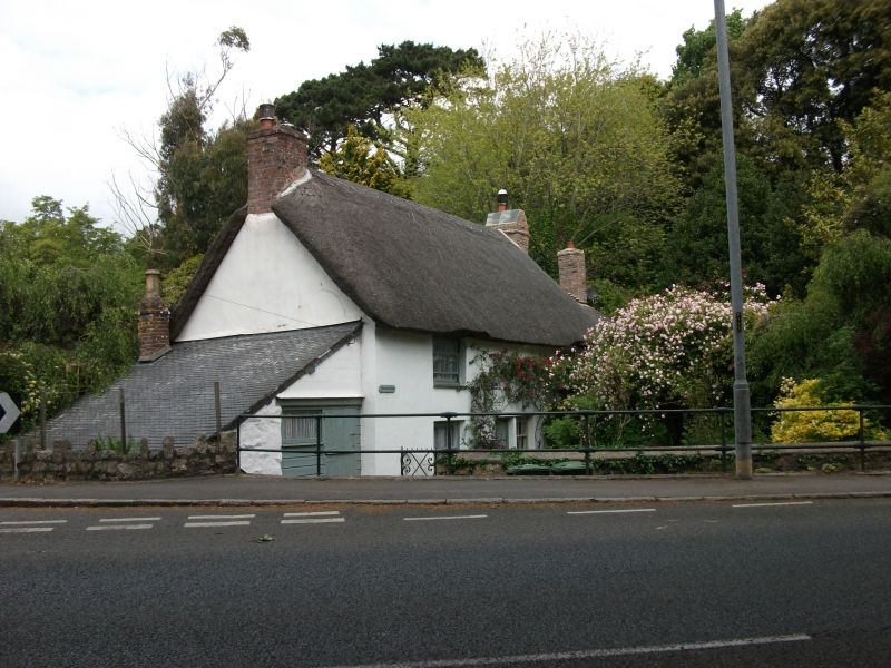
2.
C17/18 cottage. Stuccoed rubble and cob. Thatched roof with gable ends. 2
storeys. 2 windows, wide spaced small sashes with glazing bars. Lean-to additions
at both ends. Modern glazed door. Sited on a bend facing down main road.
Listing NGR: SW4629530139
External links are from the relevant listing authority and, where applicable, Wikidata. Wikidata IDs may be related buildings as well as this specific building. If you want to add or update a link, you will need to do so by editing the Wikidata entry.


Other nearby listed buildings
