Approximate Location Map
Large Map »
Latitude: 50.1193 / 50°7'9"N
Longitude: -5.4783 / 5°28'41"W
OS Eastings: 151452
OS Northings: 30153
OS Grid: SW514301
Mapcode National: GBR DXVC.HFR
Mapcode Global: VH130.085C
Plus Code: 9C2P4G9C+PM
Entry Name: The Harbour Walls and Bollards
Listing Date: 9 October 1987
Grade: II*
Source: Historic England
Source ID: 1143786
English Heritage Legacy ID: 69944
ID on this website: 101143786
Location: Marazion, Cornwall, TR17
County: Cornwall
Civil Parish: St. Michael's Mount
Traditional County: Cornwall
Lieutenancy Area (Ceremonial County): Cornwall
Tagged with: Architectural structure
MARAZION ST MICHAEL'S MOUNT
SW 5130
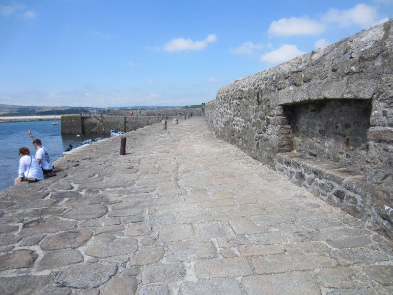
4/34 (was part of 9/157) The harbour walls and bollards
GV II*
Harbour walls and bollards. Originally built circa early C15 for William Moreton,
archpriest of the Mount, remodelled circa 1727 for Sir John St Aubyn, the third
baronet and largely rebuilt in 1824 for Sir John St Aubyn, the fifth baronet, in
1824. Granite rubble and dressed granite cast-iron bollards (some of which are
reused cannons).
Plan: Irregular enclosure walled on 4 sides, the south side a retaining wall against
the north shore of the island, the north wall with a large harbour entrance, the east
wall adjoining the causeway to the mainland and the west wall incorporating a raised
walk behind the parapets. Steps inside the harbour on either side of the entrances,
2 flights steps up to a projecting quay on the south side of the harbour and 3
slipways leading to the south-east and south west corners of the harbour. Bollards
ranged slightly irregularly along the quays. Parapets on the seawards side of the 3
projecting walls. The walls of the harbour are slightly battered. The lower parts
of some of the walls are of large roughly-hewn irregularly coursed blocks possibly
C18 or earlier, above this in places are vertically set stones probably C18,
otherwise the upper parts of the walls, steps, coping stones and the paved surfaces
are probably mostly C19.
Sources : St Michael's Mount, by John St Aubyn;
the National Trust guide pamphlets.
Listing NGR: SW5145630188
External links are from the relevant listing authority and, where applicable, Wikidata. Wikidata IDs may be related buildings as well as this specific building. If you want to add or update a link, you will need to do so by editing the Wikidata entry.


Other nearby listed buildings
