Approximate Location Map
Large Map »
Latitude: 50.1176 / 50°7'3"N
Longitude: -5.5371 / 5°32'13"W
OS Eastings: 147242
OS Northings: 30162
OS Grid: SW472301
Mapcode National: GBR DXQC.LHM
Mapcode Global: VH05H.Z93P
Plus Code: 9C2P4F97+25
Entry Name: 8, Parade Street
Listing Date: 29 July 1950
Grade: II
Source: Historic England
Source ID: 1143949
English Heritage Legacy ID: 69543
ID on this website: 101143949
Location: Penzance, Cornwall, TR18
County: Cornwall
Civil Parish: Penzance
Built-Up Area: Penzance
Traditional County: Cornwall
Lieutenancy Area (Ceremonial County): Cornwall
Church of England Parish: Penzance St Mary the Virgin with St Paul
Church of England Diocese: Truro
Tagged with: Building
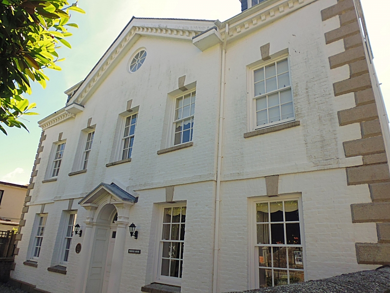
1.
1498 PENZANCE
PARADE STREET
No 8
SW 4730 5/63 29.7.50.
II
2.
C18. Colour-washed brick, long and short quoins. 3 window pedimented centre
break forward. Slate half-hipped roof. Circular window in pediment, Modillion
eaves cornice. 2 storeys. 5 windows, keyblocks, sashes with glazing bars.
Doorway, 2 Doric columns, open pediment semi-circular fanlight with gothic
glazing bars.
Listing NGR: SW4724230162
External links are from the relevant listing authority and, where applicable, Wikidata. Wikidata IDs may be related buildings as well as this specific building. If you want to add or update a link, you will need to do so by editing the Wikidata entry.


Other nearby listed buildings
