Approximate Location Map
Large Map »
Latitude: 50.3314 / 50°19'53"N
Longitude: -4.7558 / 4°45'20"W
OS Eastings: 203967
OS Northings: 51578
OS Grid: SX039515
Mapcode National: GBR N1.XG77
Mapcode Global: FRA 08X5.520
Plus Code: 9C2Q86JV+HM
Entry Name: 2, Quay Road
Listing Date: 11 March 1974
Grade: II
Source: Historic England
Source ID: 1144297
English Heritage Legacy ID: 70695
ID on this website: 101144297
Location: Charlestown, Cornwall, PL25
County: Cornwall
Civil Parish: St Austell Bay
Built-Up Area: St Austell
Traditional County: Cornwall
Lieutenancy Area (Ceremonial County): Cornwall
Church of England Parish: Charlestown
Church of England Diocese: Truro
Tagged with: House
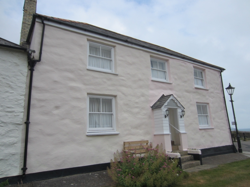
CHARLESTOWN
1. QUAY ROAD
1584A
No 2
SX 0351 NE 4/43
II GV
2.
Late C18. Colour-washed stone rubble. 2 storeys. 3 sash windows no
glazing bars. Central gabled porch granite steps. Cement washed slate
roof hipped. Included for group value.
Nos 2 to 16 (consec) form a good group.
Listing NGR: SX0396751577
External links are from the relevant listing authority and, where applicable, Wikidata. Wikidata IDs may be related buildings as well as this specific building. If you want to add or update a link, you will need to do so by editing the Wikidata entry.


Other nearby listed buildings
