Approximate Location Map
Large Map »
Latitude: 54.7148 / 54°42'53"N
Longitude: -3.4995 / 3°29'58"W
OS Eastings: 303498
OS Northings: 536560
OS Grid: NY034365
Mapcode National: GBR 4F0X.5P
Mapcode Global: WH5YB.6RTG
Plus Code: 9C6RPG72+W6
Entry Name: 72, High Street
Listing Date: 27 May 1977
Grade: II
Source: Historic England
Source ID: 1144677
English Heritage Legacy ID: 71831
ID on this website: 101144677
Location: Maryport, Cumberland, Cumbria, CA15
County: Cumbria
District: Allerdale
Civil Parish: Maryport
Built-Up Area: Maryport
Traditional County: Cumberland
Lieutenancy Area (Ceremonial County): Cumbria
Church of England Parish: Maryport St Mary with Christ Church
Church of England Diocese: Carlisle
Tagged with: Building
This list entry was subject to a Minor Enhancement on 20 July 2022 to amend the description and to reformat the text to current standards
NY 0556
1/60
MARYPORT
HIGH STREET (west side)
No 72
II
Maryport is a mid-C18 Cumbrian town and port, succeeding a small settlement and harbour known as Ellenfoot (Alnfoot), established on a planned grid pattern by Humphrey Senhouse (1731-1814) to serve the local coal mining and iron industry and function as a minor shipping point. The town officially became known as Maryport in 1756 after Humphrey Senhouse’s wife, although it had unofficially been referred to as such since the 1750s. During the C19 the town and port expanded to serve the local iron and steel industries as the town’s shipbuilding industry developed, and by the mid-C19 coal exporting had declined and the railway was introduced. The port and town remained important on the West Cumberland Coast but declined with the cessation of major industrial activity from the late 1920s. Maryport has been known as a destination for sea-bathing since the late C18.
The High Street runs north to south along an elevated ridge, which forms the historic core of the town, and may have much earlier origins than the mid-C18 planned town, even potentially utilised as part of a Roman road from the fort to the River Ellen. The grid street pattern was laid out by the mid-C18 at the dipped junction with Shipping Brow and Senhouse Street, and historically it was a mixed area of higher status residences and small commercial businesses. By the early C19 it formed the main north-south orientated throughfare, with Crosby Street, through the town. This building was one of a series of buildings along this street that served as shops and residences. 72 High Street served as an upholsterer’s shop for much of the late C19.
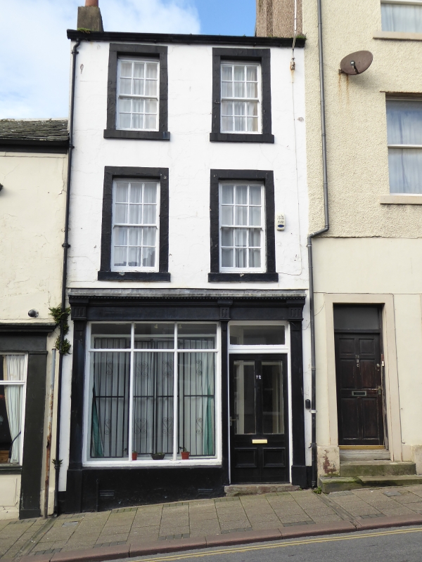
Early-C19 three-storey rendered building with a ground-floor shopfront with a half-glazed door and narrow pilasters supporting a fascia and cornice. The upper floors each have two sash windows with glazing bars, which are probably later.
Listing NGR: NY0349836560
External links are from the relevant listing authority and, where applicable, Wikidata. Wikidata IDs may be related buildings as well as this specific building. If you want to add or update a link, you will need to do so by editing the Wikidata entry.


Other nearby listed buildings
