Approximate Location Map
Large Map »
Latitude: 54.7144 / 54°42'51"N
Longitude: -3.5002 / 3°30'0"W
OS Eastings: 303453
OS Northings: 536525
OS Grid: NY034365
Mapcode National: GBR 4F0X.0S
Mapcode Global: WH5YB.6RHQ
Plus Code: 9C6RPF7X+QW
Entry Name: 13 Senhouse Street
Listing Date: 27 May 1977
Last Amended: 31 October 2022
Grade: II
Source: Historic England
Source ID: 1144646
English Heritage Legacy ID: 71854
ID on this website: 101144646
Location: Maryport, Cumberland, Cumbria, CA15
County: Cumbria
District: Allerdale
Civil Parish: Maryport
Built-Up Area: Maryport
Traditional County: Cumberland
Lieutenancy Area (Ceremonial County): Cumbria
Church of England Parish: Maryport St Mary with Christ Church
Church of England Diocese: Carlisle
Tagged with: Building
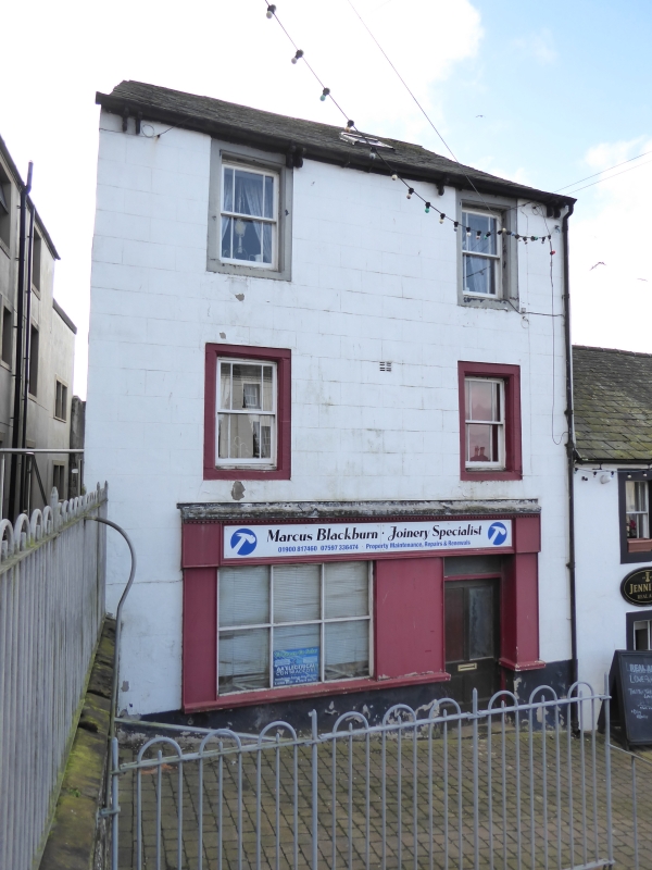
House, late C18 with later shop front.
House, late C18 with later shop front.
MATERIALS: stucco, etched to resemble stone blocks; stone slates to roof.
EXTERIOR: situated on the south side of Shipping Brow. It has two bays and three storeys beneath a pitched roof of stone slates, with bracketed eaves. The ground floor has a wide shop front with a timber cornice and a dentilled facia, and a shop window of six large panes. There are later double doors to the right below a rectangular fanlight. The first and second floors each have two windows in stone surrounds with chamfered reveals and one-over-one sliding sash windows with margin lights. The style of these chamfers, which are present on other buildings in this part of Senhouse Street, suggests a late C18 date. There is a single roof light.
Maryport is a mid-C18 Cumbrian town and port, succeeding a small settlement and harbour known as Ellenfoot (Alnfoot), established on a planned grid pattern by Humphrey Senhouse (1731-1814) to serve the local coal mining and iron industry, and function as a minor shipping point. The town officially became known as Maryport in 1756 after Humphrey Senhouse’s wife, although it had unofficially been referred to as such since the earlier 1750s. During the C19 the town and port expanded to serve the local iron and steel industries as the town’s shipbuilding industry developed, and by the mid-C19 coal exporting had declined and the railway was introduced. The port and town remained important on the west Cumberland coast but declined with the cessation of major industrial activity from the late 1920s. Maryport has been known as a destination for sea bathing since the late C18.
Senhouse Street, running from Curzon Street to the harbour, retains its historic layout of diverse and varied C18 and C19 buildings. Its north-west end is known as Shipping Brow and forms the earliest part of the mid-C18 grid pattern. It is labelled as the town’s earliest marketplace, known as Old Market Brow, on a map of around 1756, and as a consequence is wider than other streets in the town with continuous rows of houses north and south (now with a handful of buildings removed). By the early C19, it was no longer the official marketplace, but remained a prominent residential and commercial area, with those involved in the town’s principal industries residing there.
13 Senhouse Street, Maryport is listed at Grade II for the following principal reasons:
Architectural interest:
* dating from the late C18, when there is a presumption in favour of listing buildings which retain a significant proportion of their historic fabric;
* it largely retains its original late-C18 domestic character including chamfered reveals to the upper windows.
Historic interest:
* as one of the key buildings on Shipping Brow that formed the earliest part of the mid-C18 planned town.
Group value:
* it benefits from a group value with several C18 and C19 domestic and commercial buildings, which together combine to impart the historic character of this part of Maryport.
External links are from the relevant listing authority and, where applicable, Wikidata. Wikidata IDs may be related buildings as well as this specific building. If you want to add or update a link, you will need to do so by editing the Wikidata entry.


Other nearby listed buildings
