Approximate Location Map
Large Map »
Latitude: 54.5345 / 54°32'4"N
Longitude: -2.3906 / 2°23'26"W
OS Eastings: 374824
OS Northings: 515538
OS Grid: NY748155
Mapcode National: GBR CJR0.79
Mapcode Global: WH937.79W4
Plus Code: 9C6VGJM5+QQ
Entry Name: Bridge End House
Listing Date: 21 June 1984
Grade: II
Source: Historic England
Source ID: 1144864
English Heritage Legacy ID: 73394
ID on this website: 101144864
Location: Warcop, Westmorland and Furness, Cumbria, CA16
County: Cumbria
District: Eden
Civil Parish: Warcop
Traditional County: Westmorland
Lieutenancy Area (Ceremonial County): Cumbria
Church of England Parish: Warcop St Columba
Church of England Diocese: Carlisle
Tagged with: House
NY 7415 WARCOP B6259 WARCOP
(north side)
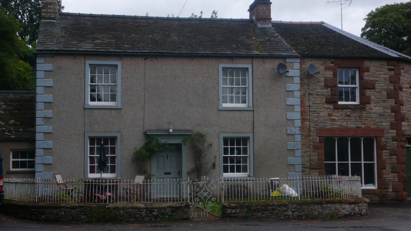
17/110 Bridge End House
G.V. II
House, late C18/early C19. Rendered rubble with rusticated quoins. Graduated
slate roof with end chimneys, 1 brick, 1 stone. Symmetrical 2-storey, 3-bay
front has central panelled door in architrave; single sash with glazing bars in
stone surround to either side on each floor. Garage adjoining west end not
included.
Listing NGR: NY7482415538
External links are from the relevant listing authority and, where applicable, Wikidata. Wikidata IDs may be related buildings as well as this specific building. If you want to add or update a link, you will need to do so by editing the Wikidata entry.


Other nearby listed buildings
