Uploader's Comments
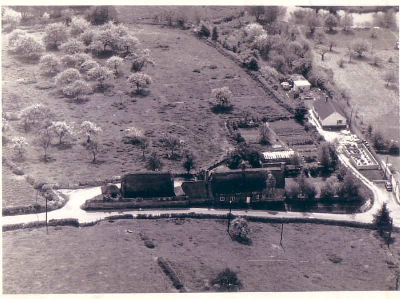
I was told that this photograph was taken by the RAF in 1965 & I own the original photograph today. It shows Ugford Farmhouse with its thatched wooden barn to the left this was raised to the ground around 1976; I was about 10 years old & remember the fire.
Ugford was mentioned in the Doomsday book and its name is a corruption of the name Orcheford which it was known to be called in 1090. This is particularly relevant as there has always been a multitude of apple trees in North Ugford and it was believed that Ugford Farmhouse was built of the site of a Nunnery that serviced the apple orchards of that time. I have a copy of a 1908 map of Ugford that shows apple orchards in front of Ugford Farmhouse as well as behind and to the right of the picture. Today only a handful of apple trees can be found and almost none at the Farmhouse.
In the field behind the farmhouse you can see an outline marked in the ground. I was told that this was an old tennis court and this shows on my 1929 map as being tied to that land.
I believe that the whole of this land belonged to Wilton Estate and that the farmhouse was let out to tenant farmers. Mr S. Christopher lived there between 1960 – 1980.
Uploaded by Chris Rawson on 5 June 2012


