Approximate Location Map
Large Map »
Latitude: 54.4869 / 54°29'12"N
Longitude: -0.612 / 0°36'43"W
OS Eastings: 490013
OS Northings: 511059
OS Grid: NZ900110
Mapcode National: GBR SJ5K.9B
Mapcode Global: WHG9Y.KHS4
Plus Code: 9C6XF9PQ+Q5
Entry Name: 6, Grape Lane
Listing Date: 4 November 1965
Grade: II
Source: Historic England
Source ID: 1148245
English Heritage Legacy ID: 326794
ID on this website: 101148245
Location: Whitby, North Yorkshire, YO22
County: North Yorkshire
District: Scarborough
Civil Parish: Whitby
Built-Up Area: Whitby
Traditional County: Yorkshire
Lieutenancy Area (Ceremonial County): North Yorkshire
Church of England Parish: Whitby St Mary
Church of England Diocese: York
Tagged with: Building
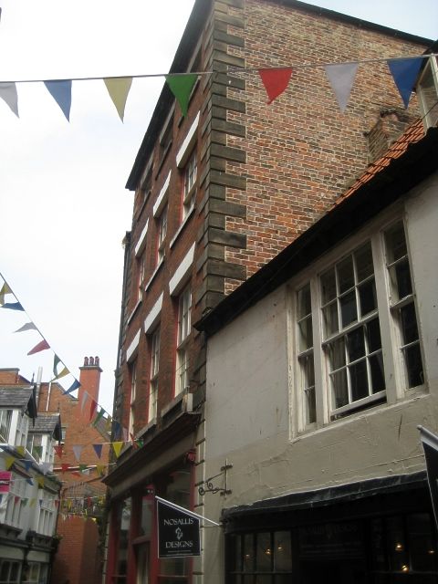
1.
1811 GRAPE LANE
(North Side)
No 6
NZ 9011 2/131 4.11.65
II GV
2.
Early C19. 4 storeys in brick. 3 windows, stone flat arches, double-hung
sashes with glazing bars. Rusticated stone quoins. Stone cornice and blocking
course. Modern ground floor shop front.
Nos 6 to 11 (consec) form a group.
Listing NGR: NZ9001311059
External links are from the relevant listing authority and, where applicable, Wikidata. Wikidata IDs may be related buildings as well as this specific building. If you want to add or update a link, you will need to do so by editing the Wikidata entry.


Other nearby listed buildings
