Approximate Location Map
Large Map »
Latitude: 54.4296 / 54°25'46"N
Longitude: -1.5367 / 1°32'12"W
OS Eastings: 430155
OS Northings: 503895
OS Grid: NZ301038
Mapcode National: GBR KKQ6.3W
Mapcode Global: WHC69.CXHL
Plus Code: 9C6WCFH7+R8
Entry Name: Grave-Slab in St Mary's Churchyard, to North of Centre
Listing Date: 11 April 1986
Grade: II
Source: Historic England
Source ID: 1150205
English Heritage Legacy ID: 332051
ID on this website: 101150205
Location: St Mary's Burial Ground, North Yorkshire, DL7
County: North Yorkshire
District: Hambleton
Civil Parish: East Cowton
Traditional County: Yorkshire
Lieutenancy Area (Ceremonial County): North Yorkshire
Tagged with: Architectural structure
EAST COWTON NORTH COWTON ROAD
NZ 30 SW
(North Side)
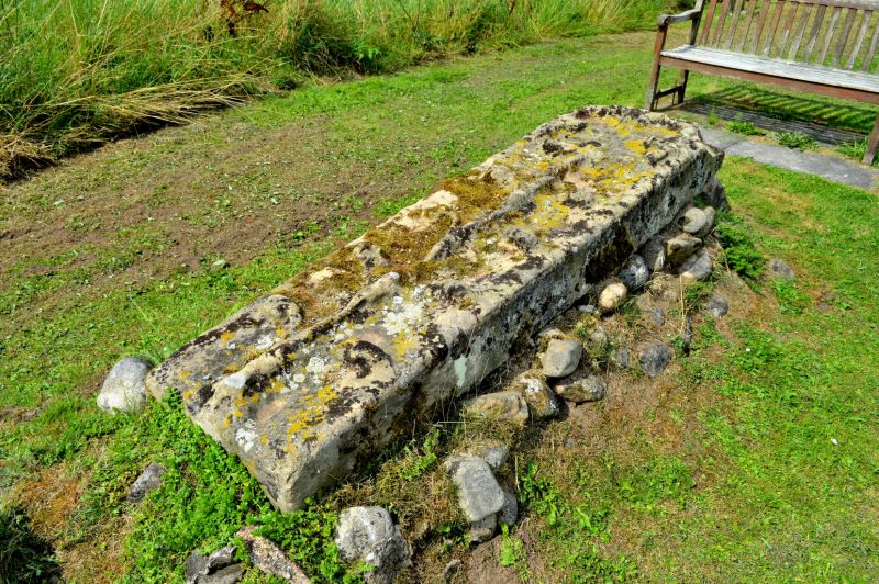
3/6a Grave-slab in St Mary's
- Churchyard, to north of
centre
- II
Grave-slab. C14. Stone slab. Plain, the top having relief carving of foliate
cross with leafed stems to shaft. Marks the site of the medieval church
demolished c1960 (churchyard still in use).
Listing NGR: NZ3015503895
External links are from the relevant listing authority and, where applicable, Wikidata. Wikidata IDs may be related buildings as well as this specific building. If you want to add or update a link, you will need to do so by editing the Wikidata entry.


Other nearby listed buildings
