Approximate Location Map
Large Map »
Latitude: 53.9652 / 53°57'54"N
Longitude: -1.2882 / 1°17'17"W
OS Eastings: 446794
OS Northings: 452361
OS Grid: SE467523
Mapcode National: GBR MQFL.XB
Mapcode Global: WHD9W.5LTK
Plus Code: 9C5WXP86+3P
Entry Name: Brewery Farmhouse
Listing Date: 8 October 1987
Grade: II
Source: Historic England
Source ID: 1150337
English Heritage Legacy ID: 331750
ID on this website: 101150337
Location: Tockwith, North Yorkshire, YO26
County: North Yorkshire
District: Harrogate
Civil Parish: Tockwith
Built-Up Area: Tockwith
Traditional County: Yorkshire
Lieutenancy Area (Ceremonial County): North Yorkshire
Church of England Parish: Marston Moor
Church of England Diocese: York
Tagged with: Farmhouse
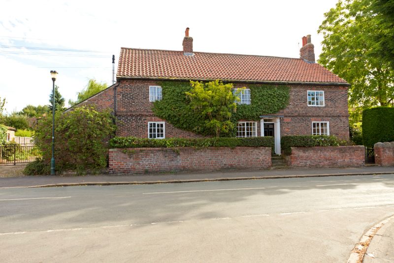
SE 45 SE TOCKWITH WESTFIELD ROAD
(south side)
4/48 Brewery Farmhouse
GV II
House. Early-mid C18, restored late C20. Red-brown brick, random bond; C20
pantile roof with one eaves course of stone slates. 2 storeys, 3 x 2 bays.
5 steps up to 6-panel door with overlight to right of bay 2, in a slender
pilastered doorcase. Square windows with 12-pane side-sliding sashes, bays
1 and 3; larger windows of 24 panes (ground floor) and 18 panes to bay 2. A
narrow blocked window to right of door. Flat stretcher arches to ground
floor windows. Projecting first-floor band; dentilled eaves cornice. Ridge
stack between bays 1 and 2 and right. Lean-to addition to left, not of
special interest. Interior: large open fireplace with wooden bressumer
altered at restoration; straight cut chamfer stops with bar to cross beams
of ground-floor rooms.
Listing NGR: SE4679452361
External links are from the relevant listing authority and, where applicable, Wikidata. Wikidata IDs may be related buildings as well as this specific building. If you want to add or update a link, you will need to do so by editing the Wikidata entry.


Other nearby listed buildings
