Approximate Location Map
Large Map »
Latitude: 53.541 / 53°32'27"N
Longitude: -1.2261 / 1°13'33"W
OS Eastings: 451382
OS Northings: 405211
OS Grid: SE513052
Mapcode National: GBR MWWH.BC
Mapcode Global: WHDD1.48D6
Plus Code: 9C5WGQRF+CH
Entry Name: Shelter Shed Approximately 40 Metres to North of Manor Farmhouse
Listing Date: 11 April 1986
Grade: II
Source: Historic England
Source ID: 1151641
English Heritage Legacy ID: 334554
ID on this website: 101151641
Location: Marr, Doncaster, South Yorkshire, DN5
County: Doncaster
Civil Parish: Marr
Traditional County: Yorkshire
Lieutenancy Area (Ceremonial County): South Yorkshire
Church of England Parish: Bilham
Church of England Diocese: Sheffield
Tagged with: Agricultural structure
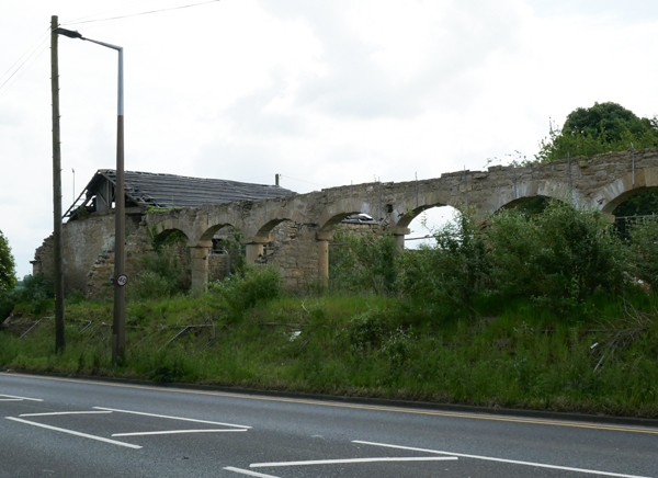
SE50NW MARR BARNSLEY ROAD
(south side)
5/133 Shelter shed approximately
40 metres to north of
Manor Farm Farmhouse
GV II
Shelter shed. Probably early C19. Limestone ashlar arcade, rubble walling,
stone slate eaves courses to pantile roof (partly removed). Single-storey,
10-bay arcade with short wing under same roof to front right. Cylindrical piers
and square capitals to segmental arches with projecting ktiystones. Wall partition
divides 3 bays to right which have no roof covering. Wing on right has door with
small window opening on its left, hipped roof. Right return: contemporary end block
of range has large quoins, 2 segmental arches at basement level with bull-nosed pier,
square-faced surround to boarded opening above. Extension to left, under same roof
has another segmental archway with boarded doors.
Listing NGR: SE5138205211
External links are from the relevant listing authority and, where applicable, Wikidata. Wikidata IDs may be related buildings as well as this specific building. If you want to add or update a link, you will need to do so by editing the Wikidata entry.


Other nearby listed buildings
