Latitude: 50.6265 / 50°37'35"N
Longitude: -2.1208 / 2°7'14"W
OS Eastings: 391551
OS Northings: 80759
OS Grid: SY915807
Mapcode National: GBR 227.QLY
Mapcode Global: FRA 67FF.5KN
Plus Code: 9C2VJVGH+HM
Entry Name: Barn South East of Blackmanston Farm House
Listing Date: 2 October 1984
Grade: II
Source: Historic England
Source ID: 1152143
English Heritage Legacy ID: 108686
ID on this website: 101152143
Location: Steeple, Dorset, BH20
County: Dorset
Civil Parish: Steeple with Tyneham
Traditional County: Dorset
Lieutenancy Area (Ceremonial County): Dorset
Church of England Parish: Steeple with Tyneham St Michael and All Angels
Church of England Diocese: Salisbury
Tagged with: Barn
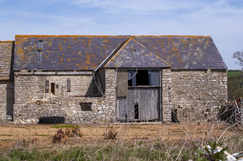
SY98SW MORETON BLACKMANSTON
9/229
Barn south-east of
Blackmanston Farm
House
GV
II
Barn. Probably C18 - appears of two builds. At right angles to road. East section
has rubble stone walls and slate roof. Single-storey. Projecting cart porch on
south with hipped roof, flanked by slate-roofed lean-to. West section has stone
slate roof. Ledged doors and simple casements. Included for group value.
Listing NGR: SY9155180759
External links are from the relevant listing authority and, where applicable, Wikidata. Wikidata IDs may be related buildings as well as this specific building. If you want to add or update a link, you will need to do so by editing the Wikidata entry.


Other nearby listed buildings