Approximate Location Map
Large Map »
Latitude: 52.5456 / 52°32'44"N
Longitude: 1.3014 / 1°18'5"E
OS Eastings: 623949
OS Northings: 299317
OS Grid: TM239993
Mapcode National: GBR VHD.KT7
Mapcode Global: VHL8K.H8WW
Plus Code: 9F43G8W2+6H
Entry Name: Remains of Church of St Botolph
Listing Date: 26 November 1959
Grade: II
Source: Historic England
Source ID: 1152430
English Heritage Legacy ID: 226668
ID on this website: 101152430
Location: Hawes' Green, South Norfolk, NR15
County: Norfolk
District: South Norfolk
Civil Parish: Shotesham
Traditional County: Norfolk
Lieutenancy Area (Ceremonial County): Norfolk
Church of England Parish: Shotesham All Saints
Church of England Diocese: Norwich
Tagged with: Church ruin
TM 29 NW
6/9
26/11/59
SHOTESHAM
HAWES' GREEN
Remains of Church of St Botolph
II
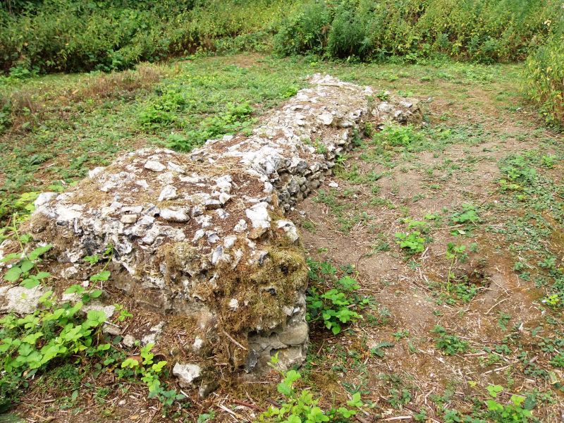
Former parish church. Medieval. Fragmentary flint remains of former west
tower.
Listing NGR: TM2394999317
External links are from the relevant listing authority and, where applicable, Wikidata. Wikidata IDs may be related buildings as well as this specific building. If you want to add or update a link, you will need to do so by editing the Wikidata entry.


Other nearby listed buildings
