Approximate Location Map
Large Map »
Latitude: 50.608 / 50°36'28"N
Longitude: -1.9567 / 1°57'24"W
OS Eastings: 403159
OS Northings: 78694
OS Grid: SZ031786
Mapcode National: GBR 459.XSM
Mapcode Global: FRA 67SG.HHT
Plus Code: 9C2WJ25V+58
Entry Name: The White Swan
Listing Date: 21 March 1983
Grade: II
Source: Historic England
Source ID: 1152585
English Heritage Legacy ID: 108202
ID on this website: 101152585
Location: Swanage, Dorset, BH19
County: Dorset
Civil Parish: Swanage
Built-Up Area: Swanage
Traditional County: Dorset
Lieutenancy Area (Ceremonial County): Dorset
Church of England Parish: Swanage St Mary the Virgin
Church of England Diocese: Salisbury
Tagged with: Architectural structure
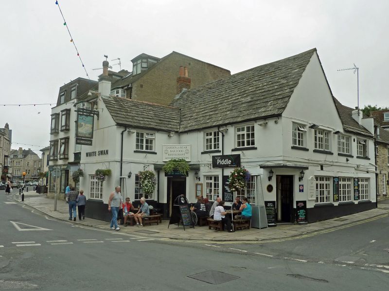
HIGH STREET
1.
5190
(south side)
No 31
The White Swan)
SZ 0378 NW 5/76 GV
II
2.
Main building C18 - possibly of earlier origin. Rendered walls. Purbeck Stone
roof - partly replaced by modern concrete slates. Two storeys. Modern casement
windows. Rear wing, facing Stafford Road - probably originally cottages - now
incorporated in the inn. Probably C18. Two storeys. Purbeck Stone walls,
modern concrete slate roof. Double-hung sash windows. RCHM Monument 37.
Listing NGR: SZ0315978694
External links are from the relevant listing authority and, where applicable, Wikidata. Wikidata IDs may be related buildings as well as this specific building. If you want to add or update a link, you will need to do so by editing the Wikidata entry.


Other nearby listed buildings
