Approximate Location Map
Large Map »
Latitude: 50.7309 / 50°43'51"N
Longitude: -1.7757 / 1°46'32"W
OS Eastings: 415928
OS Northings: 92385
OS Grid: SZ159923
Mapcode National: GBR 55J.1WY
Mapcode Global: FRA 7754.VCW
Plus Code: 9C2WP6JF+8P
Entry Name: Bandstand in Quomps Recreation Ground
Listing Date: 12 February 1976
Grade: II
Source: Historic England
Source ID: 1154149
English Heritage Legacy ID: 101624
ID on this website: 101154149
Location: Wick, Bournemouth, Christchurch and Poole, Dorset, BH23
County: Bournemouth, Christchurch and Poole
Parish: Christchurch
Built-Up Area: Christchurch
Traditional County: Hampshire
Lieutenancy Area (Ceremonial County): Dorset
Church of England Parish: Christchurch Holy Trinity
Church of England Diocese: Winchester
Tagged with: Bandstand
QUAY ROAD
1. (South West Side)
5187
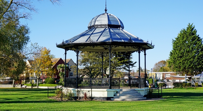
Bandstand in Quomps
Recreation Ground
SZ 1592 1A/148
II
2.
Late C19. Bandstand. Cast iron octagonal structure raised on plastered plinth.
Entrance by 5, semi-circular, steps. Cast iron balustrade and pillars. Decorative
cast iron parapet with finials around edge of roof. Wooden ribbed ceiling. Roof
surmounted by small dome with finial.
Listing NGR: SZ1592892385
External links are from the relevant listing authority and, where applicable, Wikidata. Wikidata IDs may be related buildings as well as this specific building. If you want to add or update a link, you will need to do so by editing the Wikidata entry.


Other nearby listed buildings
