Approximate Location Map
Large Map »
Latitude: 51.4531 / 51°27'11"N
Longitude: -0.9751 / 0°58'30"W
OS Eastings: 471308
OS Northings: 173179
OS Grid: SU713731
Mapcode National: GBR QLG.1J
Mapcode Global: VHDWT.1QVX
Plus Code: 9C3XF23F+6W
Entry Name: 27 Castle Street
Listing Date: 14 December 1978
Last Amended: 8 January 2024
Grade: II
Source: Historic England
Source ID: 1154654
English Heritage Legacy ID: 38796
ID on this website: 101154654
Location: Reading, Berkshire, RG1
County: Reading
Electoral Ward/Division: Abbey
Parish: Non Civil Parish
Built-Up Area: Reading
Traditional County: Berkshire
Lieutenancy Area (Ceremonial County): Berkshire
Church of England Parish: Reading St Giles
Church of England Diocese: Oxford
Tagged with: Building
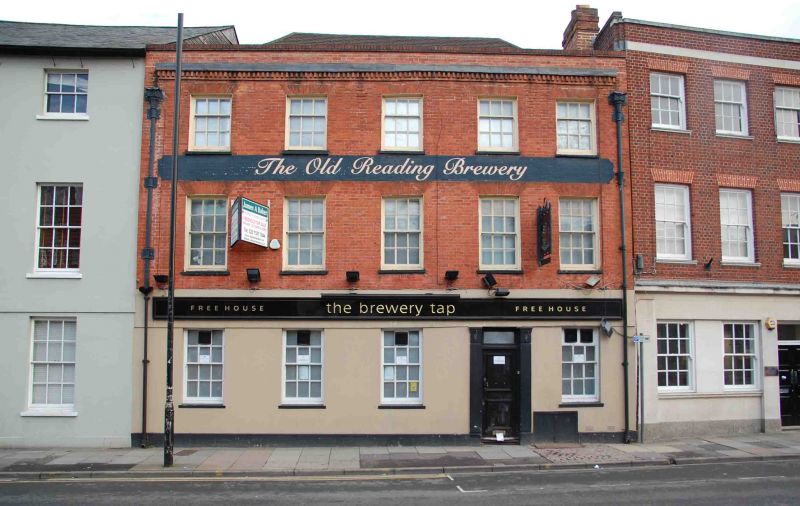
Late-C18 house, in use as a shop and brewery during the mid-C19, a public house around the 1950s, then as apartments around 2015.
Late-C18 house, in use as a shop and brewery during the mid-C19, a public house around the 1950s, then as apartments around 2015.
MATERIALS: red brick and render under a clay tile roof.
PLAN: the house has an L-shaped plan, with two lower extensions to the rear and a later range.
EXTERIOR: the principal elevation is primarily of brick in Flemish bond and faces north on to Castle Street. It is of three storeys and five bays. The ground floor is rendered over a plinth. The entrance is offset to the right side and has a C20, six-panel door with rectangular fanlight, set within a moulded doorcase. The windows to the ground floor are late C20 timber sashes with six-over-six panes, surmounted by a C20 fascia board. The upper floors have horned sashes of six over six panes, under gauged brick arches. They are divided by a painted sign with the words The OLD READING BREWERY. To either side there are large, rainwater heads. The elevation is terminated by a brick dentil cornice and parapet. The hipped roof is largely hidden.
The later range to the rear has a small, shallow-pitched section with large pane glazing and a longer, linear section of brown brick in English bond with casement windows, under a pitched, slate roof.
The crossroads formed by the north-south route of St Mary’s Butts/Bridge Street and the east-west route of Gun Street/Castle Street is believed to be the centre of the original Saxon settlement at Reading, established sometime before the ninth century, with the lowest crossing point of the River Kennet lying a short distance away to the south.
Reading was well-established by the time of the Norman Conquest, and the Domesday Book (1086) records six mills and a large estate in the town. St Mary’s Church, which lies on the north-east corner of the crossroads and was mostly rebuilt in 1551-55, was the town’s primary church until the establishment of Reading Abbey in the C12 and became so again following the Dissolution in the late 1530s.
Running west from the crossroads, Castle Street forms part of the ancient route through the town between London and the West Country, and the street historically contained many inns and guesthouses. As Reading expanded beyond its medieval limits during the C18 and C19, development spread further along Castle Street. Earlier buildings were gradually replaced with substantial townhouses and public buildings in brick or Bath stone, although some timber-framed buildings of the C16 and C17 survive.
27 Castle Street was constructed in the late C18, probably replacing an earlier building on the site. It was likely built as a large single dwelling house, but by 1851 was in use by a beer distribution company. From 1879 it is recorded as having a long, rear range and a carriage entrance to the east side of the Castle Street elevation. By the 1960s the building had been converted into a social club and around this time, the part of the rear range immediately adjoining the rear of the house was rebuilt and the carriage entrance was infilled. It is thought that there was also a shop front on the Castle Street frontage, which was removed sometime after 1978. After being used as a public house in the later C20, it was converted to apartments around 2015.
27 Castle Street, a late-C18 house, in use as a shop and brewery during the mid C19, a public house around the 1950s, then as apartments from around 2015, is listed at Grade II for the following reasons:
Architectural interest:
* as a late-C18 building which contributes to the character of an architecturally varied historic streetscape.
Historic interest:
* as part of the urban development of Reading’s ancient core.
Group value:
* the building is in close proximity to a large number of listed buildings and forms part of a strong historic grouping.
External links are from the relevant listing authority and, where applicable, Wikidata. Wikidata IDs may be related buildings as well as this specific building. If you want to add or update a link, you will need to do so by editing the Wikidata entry.


Other nearby listed buildings
