Approximate Location Map
Large Map »
Latitude: 51.4533 / 51°27'11"N
Longitude: -0.975 / 0°58'29"W
OS Eastings: 471320
OS Northings: 173199
OS Grid: SU713731
Mapcode National: GBR QLG.3G
Mapcode Global: VHDWT.1QXS
Plus Code: 9C3XF23G+82
Entry Name: 21 Castle Street
Listing Date: 14 December 1978
Last Amended: 2 January 2024
Grade: II
Source: Historic England
Source ID: 1303700
English Heritage Legacy ID: 38794
ID on this website: 101303700
Location: Reading, Berkshire, RG1
County: Reading
Electoral Ward/Division: Abbey
Parish: Non Civil Parish
Built-Up Area: Reading
Traditional County: Berkshire
Lieutenancy Area (Ceremonial County): Berkshire
Church of England Parish: Reading St Giles
Church of England Diocese: Oxford
Tagged with: Building
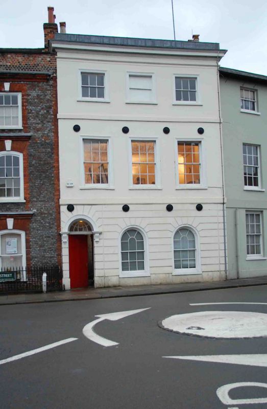
An early-C19 house, converted to a shop during the mid-C19 with the shopfronts removed and the façade restored in the late C20.
An early-C19 house, converted to a shop during the mid-C19 with the shop fronts removed and the façade restored in the late C20.
MATERIALS: stucco under a slate roof.
PLAN: the building has a dog-leg plan, with a double-pile fronting Castle Street and a longer rear range running south.
EXTERIOR: the principal elevation is of three storeys plus basement across three bays. The stucco to the ground floor is banded and divided by a plat band from the two upper floors, which are smooth rendered. The main entrance is to the left side and has a six-panel door with a decorative fanlight over, recessed within a round-arched recess supported by moulded brackets. The two, round-headed window openings to the right side each have a round-arched, timber sash with glazing bars.
The first and second floors each have three, timber sash windows set within square-headed stucco architraves, those on the first floor being larger, with six-over-six glazing, and those on the second floor having smaller, three-over-three glazed panes. Between the first and second floor is a plat band, and above the second floor there is a projecting cornice, surmounted by lead-coped parapet. There are eight, late-C20 pattress plates arranged in two rows to the upper floors.
The west elevation of the rear range is blank, while the east elevation has a variety of timber sash and casement windows to all floors. There is a door at the basement level of the south elevation, a full-height casement window and smaller, two-pane, timber sash window on the ground floor, and a tripartite timber sash window on the first and second floors.
The front range has an M-shaped roof with partially infilled roof valleys and the rear, south range has a hipped roof with brick chimney stack.
The crossroads formed by the north-south route of St Mary’s Butts/Bridge Street and the east-west route of Gun Street/Castle Street is believed to be the centre of the original Saxon settlement at Reading, established sometime before the ninth century, with the lowest crossing point of the River Kennet lying a short distance away to the south.
Reading was well-established by the time of the Norman Conquest, and the Domesday Book (1086) records six mills and a large estate in the town. St Mary’s Church, which lies on the north-east corner of the crossroads and was mostly rebuilt in 1551-1555, was the town’s primary church until the establishment of Reading Abbey in the C12 and became so again following the dissolution in the late 1530s.
Running west from the crossroads, Castle Street forms part of the ancient route through the town between London and the West Country, and the street historically contained many inns and guesthouses. As Reading expanded beyond its medieval limits during the C18 and C19, development spread further along Castle Street. Earlier buildings were gradually replaced with substantial townhouses and public buildings in brick or Bath Stone, although some timber-framed buildings of the C16 and C17 survive.
21 Castle Street was constructed during the early C19, probably on the site of an earlier building. By the mid-C19 the ground floor was in use as a shop, including a timber and glazed shopfront. The rear was extended through the later C19 and C20. The ground-floor shopfront was removed around 1990 and the façade restored. Around 2003, the building was converted to office and educational use.
21 Castle Street, an early-C19 house, converted to a shop during the mid-C19 with the shopfronts removed and the façade restored in the late C20, is listed at Grade II for the following principal reasons:
Architectural interest:
* as an early-C19 building which contributes to the character of an architecturally varied historic streetscape.
Historic interest:
* as part of the urban development of Reading’s ancient core.
Group Value:
* the building is in close proximity to a large number of listed buildings and forms part of a strong historic grouping.
External links are from the relevant listing authority and, where applicable, Wikidata. Wikidata IDs may be related buildings as well as this specific building. If you want to add or update a link, you will need to do so by editing the Wikidata entry.


Other nearby listed buildings
