Approximate Location Map
Large Map »
Latitude: 55.4758 / 55°28'32"N
Longitude: -1.6838 / 1°41'1"W
OS Eastings: 420082
OS Northings: 620265
OS Grid: NU200202
Mapcode National: GBR J5P3.7X
Mapcode Global: WHC16.3MFJ
Plus Code: 9C7WF8G8+8F
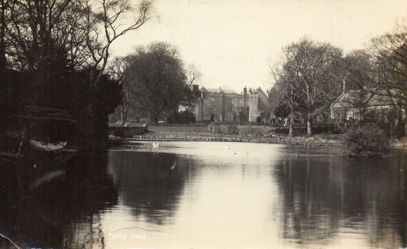
Entry Name: Rock Hall
Listing Date: 1 September 1988
Grade: II*
Source: Historic England
Source ID: 1154734
English Heritage Legacy ID: 237108
Also known as: Rock Hall, Northumberland
ID on this website: 101154734
Location: Rock, Northumberland, NE66
County: Northumberland
Civil Parish: Rennington
Traditional County: Northumberland
Lieutenancy Area (Ceremonial County): Northumberland
Church of England Parish: Rennington with Rock
Church of England Diocese: Newcastle
Tagged with: House
NU 2020 RENNINGTON ROCK VILLAGE
(West end)
15/217 Rock Hall
GV II*
House. C13 or early C14; south wing converted into a tower in late C14 or
C15; remodelled in early C17 for the Salkeld family; partly ruined after
serious fire in 1752; C19 restorations and extensions for Bosanquet family
include south front c.1820 by John Dobson and north-west wing of mid C19 by
F.R. Wilson. Medieval parts squared stone and rubble; C17 parts large rubble;
early C19 parts tooled stone with tooled ashlar dressings; north-west wing
rubble with ashlar dressings. Welsh slates on north-west wing; C20 waterproof
covering on main block roof; flat leaded roofs on early C19 parts. Complicated
plan; early medieval house probably H-plan; south wing converted into tower
with additional turret on south; C17 extensions to west of hall block; north
wing of original H-plan largely destroyed in C18 fire; two semi-octagonal 2-
storey blocks added to south front flanking turret c.1820. Mid-C19 wing
attached to north-west corner of extended hall block.
East elevation: Main part 3 storeys, 1 + 3 + 1 bays. Slightly-recessed centre
is hall block; central blocked doorway in moulded flat-pointed arch within
square frame, with Salkeld arms and cable-moulded sundial above. Castellated
bay window with wooden mullions and transoms on left is probably early C19;
other windows C17, mullioned and transomed, of 3 or 4 lights, under hoodmoulds.
Ground floor of left bay shows large squared stonework of earliest phase, with
chamfered set-back above. Inserted doorway, with vertical-panelled double
doors in bolection-moulded eared surround, flanked by small loops; straight
joint near left end shows thickening of original wall when tower constructed.
Outline of early medieval gable visible above, with inserted C17 3-light
windows to 1st and 2nd floors; embattled parapet. Right bay is largely ruined
above first floor level, but shows similar masonry and outline of early
medieval gable, with gunloop above suggesting that this wing was also raised
into a tower.
South elevation: 2 + 3 storeys, 3 irregular bays. Recessed centre is turret
of late medieval tower, with blocked loop window and old corbelled-out
parapet. Inserted C19 windows and embattled porch with flat-pointed doorway.
To either side are projecting semi-octagonal 2-storey bays with 2- and 3-light
mullioned-and-transomed windows under hoodmoulds, and embattled parapets now
partly fallen.
West elevation: 2 + 3 storeys, 5 irregular bays. Centre part is C17 wing with
original windows, with west wall of tower set back on right; in front of these
parts are castellated early C19 single-storey offices. To left of C17 wing is
early C19 three-storey part with an embattled turret; left end is north-west
wing with mullioned-and-transomed windows and a crow-stepped gable; similar
gable on left return.
Interior: No medieval or C17 features exposed, but wall thicknesses up to
1.7 metres. Entrance lobby has early C19 groined plaster ceiling; some early
C19 fireplaces with Bosanquet arms.
Historical notes. Robert de Tuggal obtained permission to conduct divine
service in his chapel here in 1359. In 1549 the hall was the headquarters of
a band of Spanish mercenaries, engaged against the Scots, under Sir Julian
Romero. It was held by the Salkelds from 1620 to 1705, who played a prominent
part in the Civil War in the area.
In use as a youth hostel at the time of survey. An important building
difficult to interpret without a full measured survey.
Listing NGR: NU2008220265
External links are from the relevant listing authority and, where applicable, Wikidata. Wikidata IDs may be related buildings as well as this specific building. If you want to add or update a link, you will need to do so by editing the Wikidata entry.


Other nearby listed buildings
