Approximate Location Map
Large Map »
Latitude: 55.0286 / 55°1'42"N
Longitude: -1.9494 / 1°56'57"W
OS Eastings: 403330
OS Northings: 570450
OS Grid: NZ033704
Mapcode National: GBR GBT9.R6
Mapcode Global: WHB22.0VZX
Plus Code: 9C7W23H2+C6
Entry Name: The Stob Stone
Listing Date: 28 April 1969
Grade: II
Source: Historic England
Source ID: 1155462
English Heritage Legacy ID: 238687
ID on this website: 101155462
Location: Northumberland, NE20
County: Northumberland
Civil Parish: Matfen
Traditional County: Northumberland
Lieutenancy Area (Ceremonial County): Northumberland
Church of England Parish: Matfen Holy Trinity
Church of England Diocese: Newcastle
Tagged with: Architectural structure
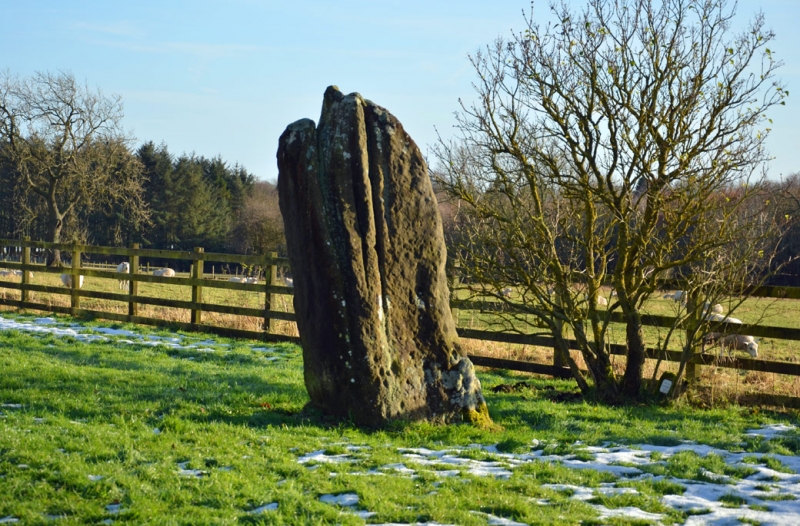
MATFEN STANDING STONE
NZ 07 SW
14/203 The Stob Stone
28.4.69
GV II
Standing stone. Prehistoric sandstone monolith c.7 ft. high forming group with
farm house. Scheduled Ancient Monument.
Listing NGR: NZ0333070450
External links are from the relevant listing authority and, where applicable, Wikidata. Wikidata IDs may be related buildings as well as this specific building. If you want to add or update a link, you will need to do so by editing the Wikidata entry.


Other nearby listed buildings
