Latitude: 51.9687 / 51°58'7"N
Longitude: -0.4342 / 0°26'3"W
OS Eastings: 507661
OS Northings: 231186
OS Grid: TL076311
Mapcode National: GBR G44.K0T
Mapcode Global: VHFR1.FS94
Plus Code: 9C3XXH98+F8
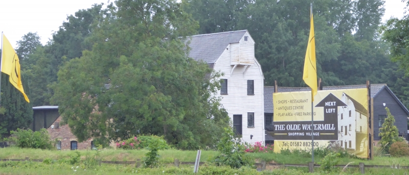
Entry Name: Barton Mill
Listing Date: 14 March 1975
Grade: II
Source: Historic England
Source ID: 1158146
English Heritage Legacy ID: 35884
Also known as: The Olde Watermill
ID on this website: 101158146
Location: Barton-le-Clay, Central Bedfordshire, MK45
County: Central Bedfordshire
Civil Parish: Barton-le-Clay
Traditional County: Bedfordshire
Lieutenancy Area (Ceremonial County): Bedfordshire
Church of England Parish: Barton-le-Cley
Church of England Diocese: St.Albans
1.
5125 BARTON-LE-CLAY MILL LANE
Barton Mill
TL 03 SE 2/25 14.3.75
II
2.
Late C18 watermill building. Weatherboarding, mansard Welsh slate roof. Three
storeys; ground and first floor central doors, projecting gabled sack hoist at
top; each floor has 2 large single windows with glazing bars, hinged in the middle
of each side, set within moulded frames. Generally modernised.
Listing NGR: TL0766131186
External links are from the relevant listing authority and, where applicable, Wikidata. Wikidata IDs may be related buildings as well as this specific building. If you want to add or update a link, you will need to do so by editing the Wikidata entry.


Other nearby listed buildings