Approximate Location Map
Large Map »
Latitude: 53.2364 / 53°14'10"N
Longitude: -1.7874 / 1°47'14"W
OS Eastings: 414287
OS Northings: 371058
OS Grid: SK142710
Mapcode National: GBR 463.4X1
Mapcode Global: WHCCZ.JX29
Plus Code: 9C5W66P7+G2
Entry Name: Milepost at Os 143 711
Listing Date: 22 March 1985
Grade: II
Source: Historic England
Source ID: 1158999
English Heritage Legacy ID: 80985
ID on this website: 101158999
Location: Taddington, Derbyshire Dales, Derbyshire, SK17
County: Derbyshire
District: Derbyshire Dales
Civil Parish: Taddington
Built-Up Area: Taddington
Traditional County: Derbyshire
Lieutenancy Area (Ceremonial County): Derbyshire
Church of England Parish: Taddington St Michael
Church of England Diocese: Derby
Tagged with: Milestone
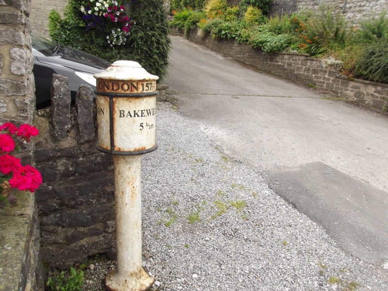
SK 17 SW PARISH OF TADDINGTON MAIN ROAD
2/73 (South Side)
Mile Post at OS 143 711
GV II
Mile post. Early C19. Cast iron. Circular shaft and broader circular body
with raised bead moulding and domed top. Inscribed around the top LONDON. The rest of the information was painted and is no longer visible.
Listing NGR: SK1428771058
External links are from the relevant listing authority and, where applicable, Wikidata. Wikidata IDs may be related buildings as well as this specific building. If you want to add or update a link, you will need to do so by editing the Wikidata entry.


Other nearby listed buildings
