Latitude: 54.6739 / 54°40'26"N
Longitude: -1.2797 / 1°16'46"W
OS Eastings: 446548
OS Northings: 531223
OS Grid: NZ465312
Mapcode National: GBR MGHD.R9
Mapcode Global: WHD6D.9SW8
Plus Code: 9C6WMPFC+H4
Entry Name: Manor Farmhouse, Adjoining Cottage and Outhouse
Listing Date: 17 December 1985
Grade: II
Source: Historic England
Source ID: 1159352
English Heritage Legacy ID: 59855
ID on this website: 101159352
Location: Dalton Piercy, Hartlepool, County Durham, TS27
County: Hartlepool
Civil Parish: Dalton Piercy
Traditional County: Durham
Lieutenancy Area (Ceremonial County): County Durham
Church of England Parish: Hart
Church of England Diocese: Durham
Tagged with: Cottage
DALTON PIERCY DALTON PIERCY VILLAGE NZ 43 SE (north side) 3/3 Manor Farmhouse, adjoining cottage and outhouse.
-- II
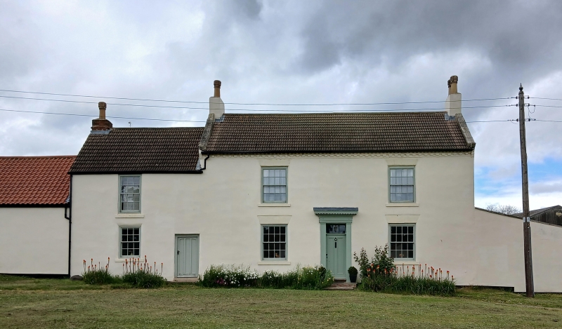
Farmhouse and cottage, now one dwelling, Early C19. Roughcast on rubble, with mid C20 concrete tile roof, brick end stacks, stone gable copings and kneelers. 2 storeys, 2 windows, symmetrical; central doorway with narrow timber pilaster-and-entablature surround, door of 2 long panels, and overlight with glazing bars. Sash windows with glazing bars, painted stone sills and lintels. Dentilled brick eaves cornice. Slightly later rear pent extension forms a cat-slide with main roof. Lower, 2-storey cottage adjoining left gable, has door of 3 long panels to right, and one sash window with painted stone sill, to each floor to left. Single- storey outhouse, adjoining left gable of cottage, has boarded door. Extensions to right gable of farmhouse are not of interest.
Listing NGR: NZ4655531223
External links are from the relevant listing authority and, where applicable, Wikidata. Wikidata IDs may be related buildings as well as this specific building. If you want to add or update a link, you will need to do so by editing the Wikidata entry.


Other nearby listed buildings