Approximate Location Map
Large Map »
Latitude: 51.6296 / 51°37'46"N
Longitude: -0.7509 / 0°45'3"W
OS Eastings: 486552
OS Northings: 193052
OS Grid: SU865930
Mapcode National: GBR D54.WG6
Mapcode Global: VHDW4.X9WK
Plus Code: 9C3XJ6HX+VJ
Entry Name: All Saints Churchyard Gates
Listing Date: 9 January 1954
Grade: II
Source: Historic England
Source ID: 1159797
English Heritage Legacy ID: 45993
ID on this website: 101159797
Location: All Saints' Church, High Wycombe, Buckinghamshire, HP11
County: Buckinghamshire
Electoral Ward/Division: Abbey
Parish: Non Civil Parish
Built-Up Area: High Wycombe
Traditional County: Buckinghamshire
Lieutenancy Area (Ceremonial County): Buckinghamshire
Church of England Parish: High Wycombe All Saints
Church of England Diocese: Oxford
Tagged with: Architectural structure
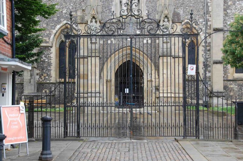
CHURCH SQUARE
1.
963
All saints' Churchyard
Gates
SU 8693 SE 2/25 9.1.54.
II GV
2.
C18, authorised by the vestry 24 July 1772. Wrought iron double gates
hung to panelled standards with scroll ornament and scroll with pattern
overthrow. Ironwork carved down at sides.
Church of All Saints, Churchyard Gates together with No 2, The Antelope
Public House, No 5 and No 6 form a group with Nos 1 to 3 (consec) High
Street.
Listing NGR: SU8655293052
External links are from the relevant listing authority and, where applicable, Wikidata. Wikidata IDs may be related buildings as well as this specific building. If you want to add or update a link, you will need to do so by editing the Wikidata entry.


Other nearby listed buildings
