Latitude: 54.5931 / 54°35'35"N
Longitude: -1.09 / 1°5'24"W
OS Eastings: 458896
OS Northings: 522371
OS Grid: NZ588223
Mapcode National: GBR NHTB.T8
Mapcode Global: WHF80.7T67
Plus Code: 9C6WHWV5+6X
Entry Name: Manor Farmhouse Adjoining Cart Shed and Outhouse
Listing Date: 29 April 1988
Grade: II
Source: Historic England
Source ID: 1160171
English Heritage Legacy ID: 60334
ID on this website: 101160171
Location: Kirkleatham, Redcar and Cleveland, North Yorkshire, TS10
County: Redcar and Cleveland
Electoral Ward/Division: Dormanstown
Parish: Non Civil Parish
Traditional County: Yorkshire
Lieutenancy Area (Ceremonial County): North Yorkshire
Church of England Parish: Kirkleatham
Church of England Diocese: York
Tagged with: Farmhouse
REDCAR KIRKLEATHAM LANE
NZ 52 SE
west side (off)
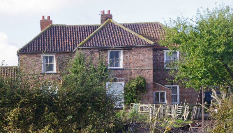
4/78 Manor Farmhouse, adjoining
cart shed and outhouse.
G.V. II
Farmhouse, mid/late C18; with flanking screen walls, altered mid/late C19,to
outhouse and cart shed. Mid C19 rear extensions and mid/late C19 porch and
front extension. Brick, on stone plinth. Clay pantile roofs with stone
ridge copings. 2 storeys, 3 bays. 6-panel door, with sidelights and
overlight, in flat-roofed porch adjoining left return of projecting middle
bay. Centre part of middle bay slightly recessed with timber and iron
lintels at eaves. Renewed sash windows with gauged brick flat arches,
keystones and painted sills. First-floor sill bands. Single-storey lean-to
extension on right return of middle bay. Late C20 metal flue at right of
3rd bay. Stepped brick eaves cornice. Hipped roof with rebuilt end and
ridge stacks. Outhouse at left and cart shed at right; each has blocked
doorway and stone band at eaves. Barns (q.v.) adjoin left and right ends.
Right return of farmhouse shows horizontal sashes with glazing bars. Rear
shows similar middle projecting bay with 16-pane sash window on first floor;
and lean-to at left with single-storey rear outhouse extension. Part of
planned farm building complex. Formerly known as Meggitts Farmhouse.
Mid/late C19 2-storey right rear extension and adjoining late C20 glazed
porch, are not of special interest.
Listing NGR: NZ5889622371
External links are from the relevant listing authority and, where applicable, Wikidata. Wikidata IDs may be related buildings as well as this specific building. If you want to add or update a link, you will need to do so by editing the Wikidata entry.


Other nearby listed buildings