Latitude: 50.2364 / 50°14'11"N
Longitude: -5.2022 / 5°12'7"W
OS Eastings: 171747
OS Northings: 42287
OS Grid: SW717422
Mapcode National: GBR Z4.QBKP
Mapcode Global: VH12K.SB53
Plus Code: 9C2P6QPX+H4
Entry Name: Pump Engine House on Site of Gambler and St Aubyn Mine at SW 717 423
Listing Date: 16 March 1987
Last Amended: 12 September 1989
Grade: II
Source: Historic England
Source ID: 1162418
English Heritage Legacy ID: 66918
ID on this website: 101162418
Location: Higher Ninnis, Cornwall, TR16
County: Cornwall
Civil Parish: St. Day
Traditional County: Cornwall
Lieutenancy Area (Ceremonial County): Cornwall
Church of England Parish: St Day
Church of England Diocese: Truro
Tagged with: Pump
ST DAY ST AUBYN
SW 74 SW
6/352
Pump engine house on site of
Gambler and St Aubyn Mine
at SW 717 423
16.3.87 (formerly listed as
Engine House at St.Aubyn)
II
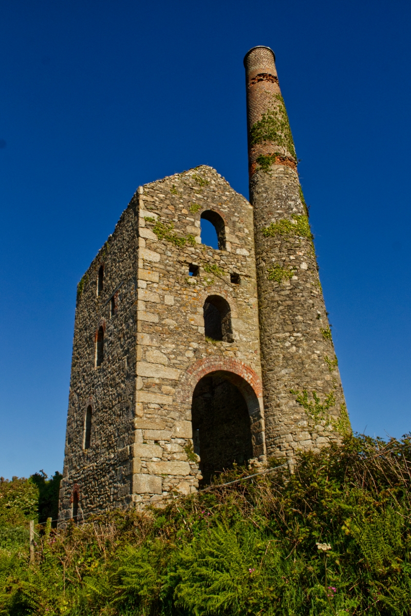
Pump engine house to former tin mine, now derelict. Probably later C19. Granite
and killas rubble with granite quoins, bob wall of large dressed granite blocks,
window arches of brick, brick upper stage to chimney; now roofless. Rectangular
plan on east-west axis, with bob wall to east, chimney attached at south-west
corner. Three stages on a high plinth, with round-headed openings including
driver's window in bob wall, large cylinder door in rear wall (the wall beneath it collapsed); 2 beam-holes between 2nd and 3rd windows in rear wall; some
square-headed openings with timber lintels in both side walls. Tapered cylindrical chimney with cornice, slightly damaged at the bottom, and some bricks missing near top of upper stage. Much of the building heavily ivy-clad at time of survey (1988). Shaft immediately in front of bob wall protected by long rectangular enclosure and lightly covered with chicken wire at time of survey.
An impressive and conspicuous landmark now isolated in rural surroundings.
Listing NGR: SW7174742286
External links are from the relevant listing authority and, where applicable, Wikidata. Wikidata IDs may be related buildings as well as this specific building. If you want to add or update a link, you will need to do so by editing the Wikidata entry.


Other nearby listed buildings