Approximate Location Map
Large Map »
Latitude: 52.3212 / 52°19'16"N
Longitude: -0.0769 / 0°4'36"W
OS Eastings: 531169
OS Northings: 270977
OS Grid: TL311709
Mapcode National: GBR K4B.KC9
Mapcode Global: VHGLY.MX6F
Plus Code: 9C4X8WCF+F6
Entry Name: New Bridges
Listing Date: 4 November 1982
Grade: II*
Source: Historic England
Source ID: 1163147
English Heritage Legacy ID: 53992
ID on this website: 101163147
Location: St Ives, Huntingdonshire, Cambridgeshire, PE27
County: Cambridgeshire
District: Huntingdonshire
Civil Parish: Saint Ives
Built-Up Area: St Ives
Traditional County: Huntingdonshire
Lieutenancy Area (Ceremonial County): Cambridgeshire
Church of England Parish: Hemingford Grey St James
Church of England Diocese: Ely
Tagged with: Bridge Road bridge
HEMINGFORD GREY
992/7/17 LONDON ROAD
04-NOV-82 (East side)
New Bridges
LONDON ROAD
New Bridges
GV II*
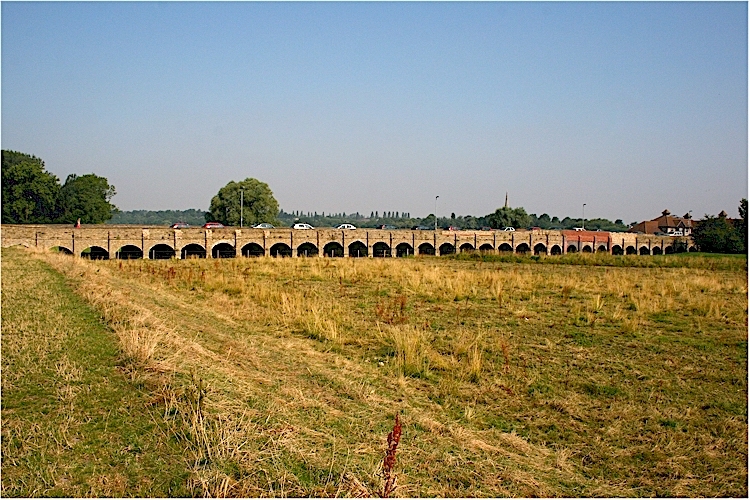
Also in Fenstanton Civil Parish. Bridge dated 1822 on plaque. Designed probably T G Elger of Bedford for the Bury-Stratton Turnpike Trust. William Biggs surveyor and John Turner probably master builder. Carved plaque now much eroded inscribed 'John Turner 1822'. Yellow gault brick, mostly stone coping to parapet with C19 brick replacement and other repairs. Fifty-five segmental arches divided by brick buttresses of two stages, lower stage with cut-water. Band at road level.
HISTORY:
Recent research has shown that the bridges were built by the Bury-Stratton Turnpike Trust although the causeway was owned by the Duke of Manchester. After the necessary loan was paid off the bridges too would become the property of the Duke. One of the trustees, John Margetts, offered a loan of £5,000 at 5% to cover all the costs, and he also provided all the bricks from his local brickworks. The architect was most probably Thomas Gwyn Elger of Bedford and William Biggs was the surveyor. The master builder appears to have been John Turner. Work began on April 8th 1822 and the 55 arches were completed in a remarkable 23 weeks. Around 1, 250 000 bricks were used. The causeway is some 700 feet long, and although there was some strengthening of a few arches when the railway was constructed across it in 1847, employing a level crossing, the causeway has only been repaired rather than widened, and much of the stone coping survives.
SUMMARY OF IMPORTANCE:
This 55 arched, single structure is a unique causeway in the UK in that it is the longest road causeway with the greatest number of continuous brick arches. It predates the brick viaducts of the railway era and is a very significant example of 'Turnpike archaeology', and was considered to be important by the engineer Thomas Telford who visited in 1826. A comparison with other causeways shows that the New Bridges is much more extensive in a single stretch and much less altered than other comparable examples.
SOURCE:
Flanagan, B, The New Bridges, Hemingford Abbots, 2005.
Listing NGR: TL3116770975
External links are from the relevant listing authority and, where applicable, Wikidata. Wikidata IDs may be related buildings as well as this specific building. If you want to add or update a link, you will need to do so by editing the Wikidata entry.


Other nearby listed buildings
