Latitude: 53.7823 / 53°46'56"N
Longitude: -2.8714 / 2°52'17"W
OS Eastings: 342677
OS Northings: 432123
OS Grid: SD426321
Mapcode National: GBR 8SDP.4X
Mapcode Global: WH85J.V6V8
Plus Code: 9C5VQ4JH+WC
Entry Name: 4 and 6, Freckleton Street
Listing Date: 11 June 1986
Last Amended: 15 September 1987
Grade: II
Source: Historic England
Source ID: 1163984
English Heritage Legacy ID: 183596
ID on this website: 101163984
Location: Kirkham, Fylde, Lancashire, PR4
County: Lancashire
District: Fylde
Civil Parish: Kirkham
Built-Up Area: Kirkham
Traditional County: Lancashire
Lieutenancy Area (Ceremonial County): Lancashire
Church of England Parish: Kirkham St Michael
Church of England Diocese: Blackburn
Tagged with: Building
In the entry for:
KIRKHAM FRECKLETON ROAD
SD 43 SW
9/26 Nos 4 and 6
-
-
The address shall be amended to read:
FRECKLETON STREET
Nos 4 and 6
------------------------------------
KIRKHAM FRECKLETON ROAD
SD 43 SW
9/26 Nos. 4 & 6
-
- II
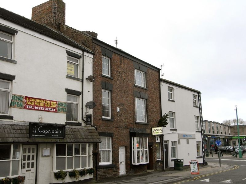
Former inn, now two houses and a shop, early C19 but altered in late Cl9.
Brick (in English garden wall bond) with stone dressings (now painted),
slate roof (also painted) with central stack and one on the left-hand
gable. 3 storeys with attic. Original windows on first and second floor
have plain reveals, stone sills and lintels with a false keystone, and
glazing bars. Right-hand window on both floors is tripartite with 12
(or 9) panes in the middle and 4(or 3) panes in each side-light. The
lintel of a similar ground floor window is half hidden behind a late C19
shop window (projecting on brackets), while what was probably the lintel of
the left-hand ground-floor window (which was widened in late C19) now sits
above a window on the far right beyond a door. Both door and window were
probably inserted in late C19. An original doorway with a gauged brick
head is situated between the left-hand window and shop window, and above it
are two blocked window openings with similar heads which probably relate to
a staircase. History: Formerly the 'Ship Inn'.
Listing NGR: SD4267732123
External links are from the relevant listing authority and, where applicable, Wikidata. Wikidata IDs may be related buildings as well as this specific building. If you want to add or update a link, you will need to do so by editing the Wikidata entry.


Other nearby listed buildings