Latitude: 51.6199 / 51°37'11"N
Longitude: 0.1037 / 0°6'13"E
OS Eastings: 545734
OS Northings: 193326
OS Grid: TQ457933
Mapcode National: GBR PY.LT8
Mapcode Global: VHHMZ.RK61
Plus Code: 9F32J493+XF
Entry Name: Millers Farmhouse
Listing Date: 29 May 1984
Grade: II
Source: Historic England
Source ID: 1165252
English Heritage Legacy ID: 118557
ID on this website: 101165252
Location: Chigwell Row, Epping Forest, Essex, IG7
County: Essex
District: Epping Forest
Civil Parish: Chigwell
Built-Up Area: Redbridge
Traditional County: Essex
Lieutenancy Area (Ceremonial County): Essex
Tagged with: Farmhouse
TQ 49 SE CHIGWELL GROVE LANE
5/4 Millers Farmhouse
II
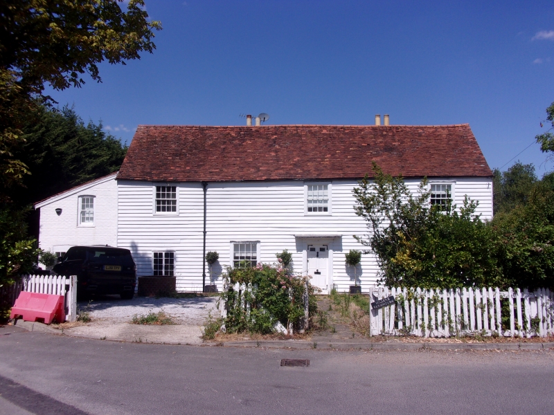
House, late C17, altered in early C19. Timber framed, weatherboarded, roofed
with handmade red clay tiles. 3 bays aligned approx. E-W, aspect S, with
central entrance stair hall and 2 chimney stacks in rear wall. Single-storey
lean-to extension at it end. Single-storey lean-to extension behind W bay, C18,
of red brick with tiled roof. Small single-storey lean-to extension in NE
angle, C20, weatherboarded with corrugated iron roof. 2 storeys with attics.
6-panel flush door, top 2 panels glazed, in simple doorcase with fluted jambs
and shallow hood, early C19, 2 double-hung sash windows of 16 lights, early
C19, 2 C20 casement windows, one plain boarded door. First floor, 3 similar
sash windows. Some framing exposed internally. Transverse beans plain
chamfered with lamb's tongue stops, some joists exposed, others plastered to
soffits. Jowled posts. 2 sets of wallplates, house originally single-storey
with attics, walls raised approx. 1 metre in late C17. Butt-purlin roof. Stair
from ground floor to attic with pine rail and square balusters, early C19.
Shutter of unusual type in E ground floor room, single, sliding sideways into
wall thickness, early Cl9. Bread oven at NW corner partly demolished, door
still present. Rear wall roughcast rendered.
Listing NGR: TQ4573493326
External links are from the relevant listing authority and, where applicable, Wikidata. Wikidata IDs may be related buildings as well as this specific building. If you want to add or update a link, you will need to do so by editing the Wikidata entry.


Other nearby listed buildings