Approximate Location Map
Large Map »
Latitude: 52.3914 / 52°23'29"N
Longitude: -2.1226 / 2°7'21"W
OS Eastings: 391756
OS Northings: 277048
OS Grid: SO917770
Mapcode National: GBR 1CY.45S
Mapcode Global: VH91X.5572
Plus Code: 9C4V9VRG+HX
Entry Name: Brook House and the Old Malt House
Listing Date: 17 July 1986
Grade: II
Source: Historic England
Source ID: 1166683
English Heritage Legacy ID: 156288
ID on this website: 101166683
Location: Belbroughton, Bromsgrove, Worcestershire, DY9
County: Worcestershire
District: Bromsgrove
Civil Parish: Belbroughton
Built-Up Area: Belbroughton
Traditional County: Worcestershire
Lieutenancy Area (Ceremonial County): Worcestershire
Church of England Parish: Belbroughton with Fairfield
Church of England Diocese: Worcester
Tagged with: Architectural structure
SO 97 NW BELBROUGHTON CP DRAYTON ROAD (north side)
Belbroughton
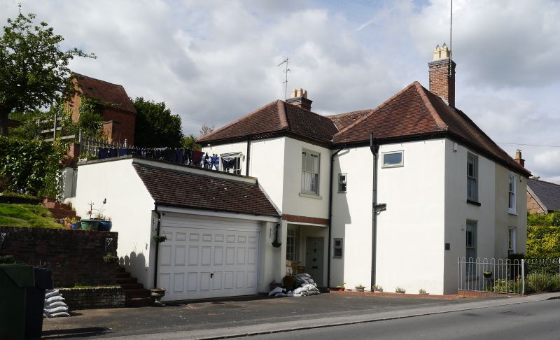
6/23 Brook House and
The Old Malt House
GV II
House divided into two dwellings. C18 with mid-C19 and mid-C20 alterations
and additions. Reddered brick with plain tiled, partly hipped roof and two
large ridge stacks. L-plan. Two storeys with cogged eaves cornice.
South elevation to road: two bays; windows are 6-pane C19 sashes. East
elevation: irregular fenestration; ground floor has two 3-light casements,
one with a cambered head, and first floor has two 16-pane sashes with
cambered heads, a 12-pane C20 casement also with a cambered head, and a C20
single-light casement; central entrance to Brook House has a C20 flat-rooted
porch with glazed.sides, a half-glazed C20 door and left side light. Interior
not inspected. A large C20 addition to the west aide includes the present
main entrance to The Malt House. The building is prominently situated along-
side the western approach into Belbroughton village and faces Island House (qv)
and the Corner House and adjoining out-buildings (qv) and is adjacent to
No 28 Drayton Road (qv).
Listing NGR: SO9175677048
External links are from the relevant listing authority and, where applicable, Wikidata. Wikidata IDs may be related buildings as well as this specific building. If you want to add or update a link, you will need to do so by editing the Wikidata entry.


Other nearby listed buildings
