Approximate Location Map
Large Map »
Latitude: 52.3356 / 52°20'8"N
Longitude: -2.0601 / 2°3'36"W
OS Eastings: 396003
OS Northings: 270839
OS Grid: SO960708
Mapcode National: GBR 2FY.G0W
Mapcode Global: VH9ZL.7KSC
Plus Code: 9C4V8WPQ+6X
Entry Name: 87A, High Street
Listing Date: 8 July 1971
Grade: II
Source: Historic England
Source ID: 1166736
English Heritage Legacy ID: 155702
ID on this website: 101166736
Location: Bromsgrove, Worcestershire, B61
County: Worcestershire
District: Bromsgrove
Electoral Ward/Division: Sanders Park
Parish: Non Civil Parish
Built-Up Area: Bromsgrove
Traditional County: Worcestershire
Lieutenancy Area (Ceremonial County): Worcestershire
Church of England Parish: Bromsgrove
Church of England Diocese: Worcester
Tagged with: Building
This list entry was subject to a Minor Amendment on 18 June 2021 to reformat the text to current standards
SO 9670 NW
3/36C
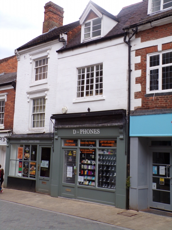
HIGH STREET (north west side)
No 87A
8.7.71.
GV
II
Late C17. Stucco. Two storeys and attic. One window, three-light mullion transom window. Modern dormer. New tiles roof. Modern shop. Included for group value.
Nos 85, building at rear of No 85, Nos 87, 87a and Nos 89 to 95 (odd) form a group.
Listing NGR: SO9600170841
External links are from the relevant listing authority and, where applicable, Wikidata. Wikidata IDs may be related buildings as well as this specific building. If you want to add or update a link, you will need to do so by editing the Wikidata entry.


Other nearby listed buildings
