Latitude: 51.8718 / 51°52'18"N
Longitude: 0.6755 / 0°40'31"E
OS Eastings: 584281
OS Northings: 222627
OS Grid: TL842226
Mapcode National: GBR QKD.PKP
Mapcode Global: VHJJL.N6FY
Plus Code: 9F32VMCG+P5
Entry Name: Highfields Farmhouse
Listing Date: 2 May 1953
Grade: II
Source: Historic England
Source ID: 1170814
English Heritage Legacy ID: 116243
ID on this website: 101170814
Location: Coggeshall, Braintree, Essex, CO6
County: Essex
District: Braintree
Civil Parish: Coggeshall
Traditional County: Essex
Lieutenancy Area (Ceremonial County): Essex
Church of England Parish: Coggeshall with Markshall
Church of England Diocese: Chelmsford
Tagged with: Farmhouse
TL 8422-8522 COGGESHALL WEST STREET (north side)
9/213 Highfields Farmhouse 2.5.53
GV II
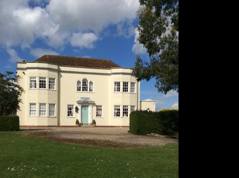
Shown on OS map as nos. 96 and 98, West Street. House. Circa 1600, altered in C18 and C19, seriously damaged by fire c.1977 and restored. Timber framed, plastered, roofed with handmade red plain tiles, and rear wing of painted brick roofed with slate. Main range facing SE, with adjacent rear wings at left and centre. C19 external stack to rear of right end. Single-storey extension with flat roof to right and rear right, connecting with an early to mid C19 house to rear with 2 internal stacks (no. 98 on OS map). C19 single-storey extension beyond with hipped slate roof, now garages. 2 storeys. 2 full-height splayed bays each with 3 C20 sashes of 12 lights at each end floor, and 2 similar sashes on the ground floor. Over central door 3 adjacent sashes, the middle one with a semi-circular head, the outer ones with ogee heads. 6-panel door, fielded, C18 doorcase with C20 rusticated jambs, pulvinated frieze, dentilled and moulded flat canopy with lead tented roof; 2 moulded limestone steps. Plain parapet. The right return has on the ground floor 2 casements with 2-centred arches and Y-tracery, and on the first floor one sash and one casement, both with 2-centred heads and Gothick tracery. The brick house to the rear right, facing NE, has a 3-window range of sashes of 16 lights with segmental arches, and another on the first floor of the left return (SE elevation). Corner pilasters, fully hipped roof. It is clear from the descriptions in RCHM iS and the Provisional List of April 1960 that since the fire the height of the main range has been reduced by one storey, and windows have been re-arranged and replicated. The RCHM reported that the house was built c.1600, but this frame cannot now be identified. The C18 dogleg stair with moulded handrail, 3 turned balusters to each tread, scrolled tread-ends and panelled dado survived the fire and has been restored. Re-used C18 pine panelling has been installed in the large entrance-hall, reported to be from Tate and Lyle, Marks Lane, City of London. Other introduced features. The fire damage did not extend to the rear wing.
Listing NGR: TL8427122620
External links are from the relevant listing authority and, where applicable, Wikidata. Wikidata IDs may be related buildings as well as this specific building. If you want to add or update a link, you will need to do so by editing the Wikidata entry.


Other nearby listed buildings