Approximate Location Map
Large Map »
Latitude: 51.8782 / 51°52'41"N
Longitude: 0.5503 / 0°33'1"E
OS Eastings: 575644
OS Northings: 223033
OS Grid: TL756230
Mapcode National: GBR PHX.7YP
Mapcode Global: VHJJJ.H290
Plus Code: 9F32VHH2+74
Entry Name: 76 and 78, High Street
Listing Date: 25 October 1951
Grade: II
Source: Historic England
Source ID: 1171330
English Heritage Legacy ID: 113756
ID on this website: 101171330
Location: Braintree, Essex, CM7
County: Essex
District: Braintree
Electoral Ward/Division: Braintree Central & Beckers Green
Parish: Non Civil Parish
Built-Up Area: Braintree
Traditional County: Essex
Lieutenancy Area (Ceremonial County): Essex
Church of England Parish: Braintree St Michael
Church of England Diocese: Chelmsford
Tagged with: Building
1.
885
TL 7523
1/110
25.10.51
HIGH STREET
(South East Side)
BRAINTREE
Nos 76 and 78
II
GV
2.
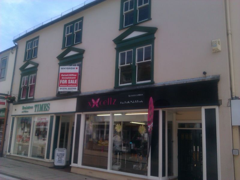
A C17 timber-framed house with a long C15 wing extending at the rear, formerly
divided into 6 bays, but now much altered. The front is C18-C19 with a 3rd
storey added. 3 storeys, 3 window range, paired double-hung sashes with single
vertical glazing bars in the upper sashes, in flush cased frames, The 1st storey
windows have stucco pediments, Roof slate. The rear has 3 gables. RCHM (14).
All the listed buildings from No 68 to No 80 on the south-east side form a group.
Listing NGR: TL7564423033
External links are from the relevant listing authority and, where applicable, Wikidata. Wikidata IDs may be related buildings as well as this specific building. If you want to add or update a link, you will need to do so by editing the Wikidata entry.


Other nearby listed buildings
