Latitude: 52.724 / 52°43'26"N
Longitude: 1.4257 / 1°25'32"E
OS Eastings: 631428
OS Northings: 319549
OS Grid: TG314195
Mapcode National: GBR WGS.77R
Mapcode Global: WHMT3.WS2K
Plus Code: 9F43PCFG+J7
Entry Name: Church of St Peter
Listing Date: 16 April 1955
Grade: II*
Source: Historic England
Source ID: 1171821
English Heritage Legacy ID: 224394
Also known as: Saint Peter Church, Hoveton
ID on this website: 101171821
Location: St Peter's Church, North Norfolk, NR12
County: Norfolk
District: North Norfolk
Civil Parish: Hoveton
Traditional County: Norfolk
Lieutenancy Area (Ceremonial County): Norfolk
Church of England Parish: Hoveton St Peter
Church of England Diocese: Norwich
Tagged with: Church building Thatched building
HOVETON ST. PETER'S LANE TG 31 NW 7/63 Church of St. Peter 16.4.55 - II*
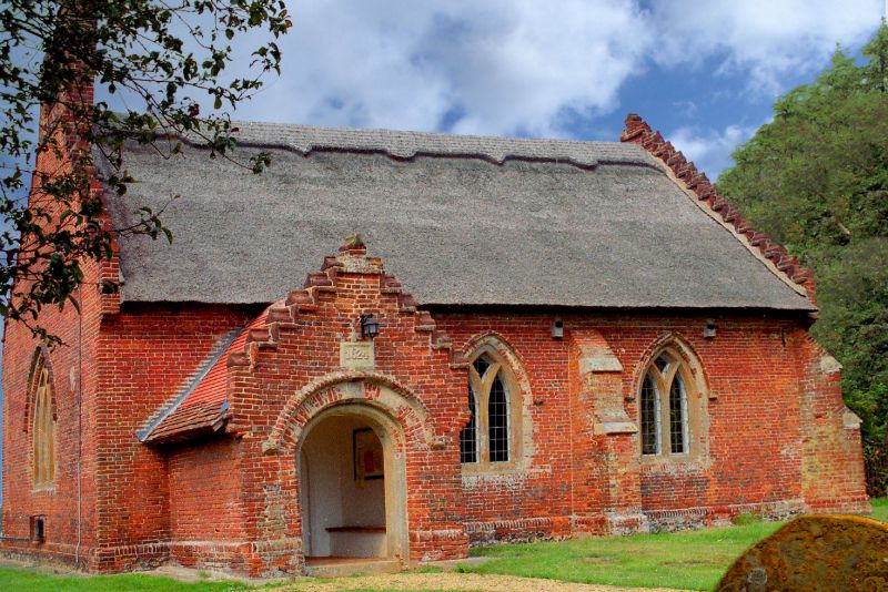
Parish church. Dated 1624, restored 1884 by H.J. Green, Diocesan architect, and 1947. Brick with thatched roof. Rectangular plan comprising undifferentiated nave and chancel. 3-light intersecting west and east windows. 2 2-light Y windows to north and south, all windows with hood moulds on labels. Brick plinth. West and east gables stepped with trefoil coping on kneelers. Bell-cote to west has rebated centre and stepped gable. Gabled south porch, the gable stepped and supported on kneelers. Double chamfered inner and outer arches are semi-circular. Outer arch with hood on labels below datestone 1624, One stepped side buttress to nave and diagonal stepped eastern buttresses, all with tumbling. South side has corbelled eaves cornice, north side a saw-toothed eaves cornice. Blocked double chamfered north door. Interior. Tie beams to now boarded roof have small sunk quadrant mouldings. Polygonal pulpit panelled and with palmette frieze below top rail. C19 linefold altar dado. Circular C19 drum font enriched by 4 patee crosses in punched roundels, otherwise plain. Asymmetrical wall monument in form of cartouche to Mary Aufrere 1750 : composed of drapery folds with cherub at apex holding coat of arms; further cherubic head to left.
Listing NGR: TG3142819549
External links are from the relevant listing authority and, where applicable, Wikidata. Wikidata IDs may be related buildings as well as this specific building. If you want to add or update a link, you will need to do so by editing the Wikidata entry.


Other nearby listed buildings