Approximate Location Map
Large Map »
Latitude: 50.9115 / 50°54'41"N
Longitude: -2.2012 / 2°12'4"W
OS Eastings: 385951
OS Northings: 112466
OS Grid: ST859124
Mapcode National: GBR 1YN.VNN
Mapcode Global: FRA 668P.Q82
Plus Code: 9C2VWQ6X+HG
Entry Name: Dovecote and Attached Open Shelter Building 60M South-West of Church Farmhouse
Listing Date: 24 June 1985
Grade: II
Source: Historic England
Source ID: 1172085
English Heritage Legacy ID: 103194
ID on this website: 101172085
Location: Shroton, Dorset, DT11
County: Dorset
Civil Parish: Iwerne Courtney or Shroton
Built-Up Area: Iwerne Courtney
Traditional County: Dorset
Lieutenancy Area (Ceremonial County): Dorset
Church of England Parish: Iwerne Courtney (Shroton) and Iwerne Steepleton St Mary
Church of England Diocese: Salisbury
Tagged with: Dovecote Thatched building
ST 8512 IWERNE COURTNEY OR SHROTON MAIN STREET
(West Side)
11/106
Dovecote and
GV attached open
shelter building
60m south-west of
Church Farmhouse
II
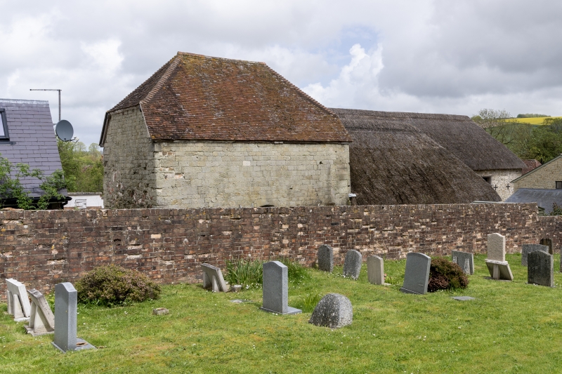
Dovecote and attached open shelter building. Dovecote C17, shelter of uncertain
date. Dovecote of ashlar with half-hipped tiled roof. Chamfered plinth. Shelter
is timber framed on stone plinths with hipped, thatched roof. Internally the
dovecote is lined with nesting boxes formed of thin stone slabs supported on
square blocks. Part of an impressive and relatively unchanged group of farm
buildings (RCHM, Dorset vol III, p 129, no 8).
Listing NGR: ST8595312470
External links are from the relevant listing authority and, where applicable, Wikidata. Wikidata IDs may be related buildings as well as this specific building. If you want to add or update a link, you will need to do so by editing the Wikidata entry.


Other nearby listed buildings
