Latitude: 54.2715 / 54°16'17"N
Longitude: -0.9339 / 0°56'1"W
OS Eastings: 469527
OS Northings: 486725
OS Grid: SE695867
Mapcode National: GBR PMX1.MK
Mapcode Global: WHF9M.MWHT
Plus Code: 9C6X73C8+HF
Entry Name: Low Hall and Garden Wall Attached to Outbuilding to Left
Listing Date: 14 July 1955
Last Amended: 5 June 1985
Grade: II
Source: Historic England
Source ID: 1173849
English Heritage Legacy ID: 328397
ID on this website: 101173849
Location: Kirkbymoorside, North Yorkshire, YO62
County: North Yorkshire
District: Ryedale
Civil Parish: Kirkbymoorside
Built-Up Area: Kirkbymoorside
Traditional County: Yorkshire
Lieutenancy Area (Ceremonial County): North Yorkshire
Church of England Parish: Kirkbymoorside All Saints
Church of England Diocese: York
Tagged with: Architectural structure
SE 6886-6986 KIKBYMOORSIDE DALE END (north side)
6/39 Low Hall, and garden wall attached to outbuilding to left (formerly listed as Low Hall)
- II
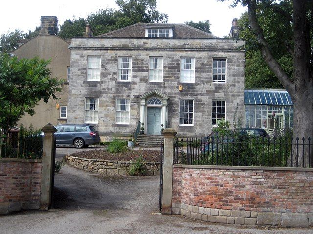
House and garden wall to left. 1797 with C19 and C20 extension and alteration. Fine ashlar front, each block with vertical and horizontal milling; rendered to sides and rear; concrete slab roof. Central stairhall plan, 1½ rooms deep, with later extension to left. 2 storeys with basement and attic. 5 bays. Central 6-panel door approached by cantilevered steps over the basement area, with cast-iron railings. Fanlight with Gothick glazing. Doorcase of open pediment on Tuscan columns. 12-pane sashes with plain lintels throughout. Raised band at basement level and naves travel, the latter supporting a plain parapet. C20 flat-topped dormer in attic. End stacks to hipped roof. To rear: round-headed staircase window with Gothick glazing. Interior: open string, dogleg staircase with square blalusters, shaped cheek-pieces and moulded handrail. Interior of staircase window is deeply splayed and has panelled reveal. Late C18 doors, and beaded and fielded window panelling survive throughout the ground floor. An undulating garden wall of the same milled stone as the house, with cambered coping, masks and outbuilding contained in the angle of the original house and the C19 extension. The C19 extension and outbuilding are not of special interest.
Listing NGR: SE6952786725
External links are from the relevant listing authority and, where applicable, Wikidata. Wikidata IDs may be related buildings as well as this specific building. If you want to add or update a link, you will need to do so by editing the Wikidata entry.


Other nearby listed buildings