Approximate Location Map
Large Map »
Latitude: 51.8098 / 51°48'35"N
Longitude: 0.1447 / 0°8'40"E
OS Eastings: 547949
OS Northings: 214529
OS Grid: TL479145
Mapcode National: GBR LD5.FDN
Mapcode Global: VHHM1.GRBY
Plus Code: 9F32R45V+WV
Entry Name: The Dell
Listing Date: 2 October 1981
Grade: II
Source: Historic England
Source ID: 1176604
English Heritage Legacy ID: 160809
ID on this website: 101176604
Location: Sawbridgeworth, East Hertfordshire, CM21
County: Hertfordshire
District: East Hertfordshire
Civil Parish: Sawbridgeworth
Built-Up Area: Sawbridgeworth
Traditional County: Hertfordshire
Lieutenancy Area (Ceremonial County): Hertfordshire
Church of England Parish: Sawbridgeworth
Church of England Diocese: St.Albans
Tagged with: Architectural structure
1.
2553
TL 479 145
976/6/8
19-AUG-03
BROOK LANE
(West side)
THE DELL
Formerly listed as
LONDON ROAD
(West Side)
The Dell
II
2.
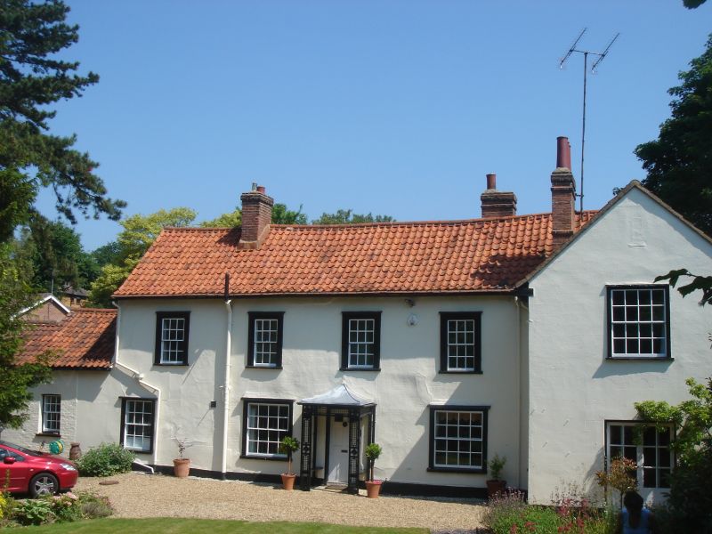
C18 or earlier building remodelled. Crosswing on E possibly C19. Timber
frame with brick at back of crosswing next road, rendered. Rear (N) wall
of main range weatherboarded. Steep red pantiled roof with bellcast to
eaves and gabled to W. Machine made tiles to crosswing. S face 2
storeys, 4 windows with plinth, plaster lined as ashlar. 1st floor has
C18 flush box sashes with moulded architraves and 6/6 panes. Gd floor
and both floors of rendered crosswing have C19 flush sashes with moulded
architraves and 8/8 panes. Central 6 panel flush beaded door, top 2 glazed,
under treillage porch with hipped roof. Large central chimney nearer W
end and former gable stack next crosswing. Lateral rear stack next
crosswing. E face of crosswing has narrow flush box sashes with 6/6 panes
and moulded architraves. Extending from W gable,1½ storey timberframed
weatherboarded building with gabled pantile roof and gable chimney. An
interesting house rather cut off by road embankment in C19.
Listing NGR: TL4794914529
External links are from the relevant listing authority and, where applicable, Wikidata. Wikidata IDs may be related buildings as well as this specific building. If you want to add or update a link, you will need to do so by editing the Wikidata entry.


Other nearby listed buildings
