Approximate Location Map
Large Map »
Latitude: 51.0541 / 51°3'14"N
Longitude: -2.7285 / 2°43'42"W
OS Eastings: 349036
OS Northings: 128562
OS Grid: ST490285
Mapcode National: GBR MK.FSMY
Mapcode Global: FRA 565B.GTM
Plus Code: 9C3V373C+MJ
Entry Name: South Boundary Wall, Railings, Gates and Piers, About 45 Metres South of St Michaels Church
Listing Date: 30 September 1985
Grade: II
Source: Historic England
Source ID: 1177409
English Heritage Legacy ID: 262972
ID on this website: 101177409
Location: St Michael's Church, Somerton, Somerset, TA11
County: Somerset
District: South Somerset
Civil Parish: Somerton
Built-Up Area: Somerton
Traditional County: Somerset
Lieutenancy Area (Ceremonial County): Somerset
Tagged with: Wall
ST49NW SOMERTON CP MARKET PLACE (North side)
9/169
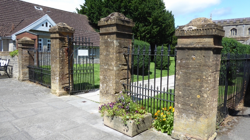
South boundary wall, railings,
gates and piers, about 45 metres
south of St Michael's Church
-
GV II
Boundary wall, railings, gate and piers. Early C19. Ham and local lias stone; wrot iron. Local stone roughly cut and
squared in west length of wall, with roll coping; gate piers about 500mm square and 2.5 metres high; plain plinths and
shafts with collars and fluted caps with ogee pyramidal tops; railings have cast iron arrow top spikes; with gates to
match, having quatrefoil decoration to middle rail. Contributing to setting of Church of St Michael (qv) and to the
street scene in the Market place.
Listing NGR: ST4903628562
External links are from the relevant listing authority and, where applicable, Wikidata. Wikidata IDs may be related buildings as well as this specific building. If you want to add or update a link, you will need to do so by editing the Wikidata entry.


Other nearby listed buildings
