Approximate Location Map
Large Map »
Latitude: 52.7001 / 52°42'0"N
Longitude: -1.0761 / 1°4'33"W
OS Eastings: 462532
OS Northings: 311783
OS Grid: SK625117
Mapcode National: GBR 9N2.QRR
Mapcode Global: WHFK9.FDTC
Plus Code: 9C4WPW2F+2H
Entry Name: 59, High Street
Listing Date: 9 October 1984
Grade: II
Source: Historic England
Source ID: 1177707
English Heritage Legacy ID: 189577
ID on this website: 101177707
Location: Syston, Charnwood, Leicestershire, LE7
County: Leicestershire
District: Charnwood
Civil Parish: Syston
Built-Up Area: Syston
Traditional County: Leicestershire
Lieutenancy Area (Ceremonial County): Leicestershire
Church of England Parish: Syston
Church of England Diocese: Leicester
Tagged with: Building
SK 6211
9/111
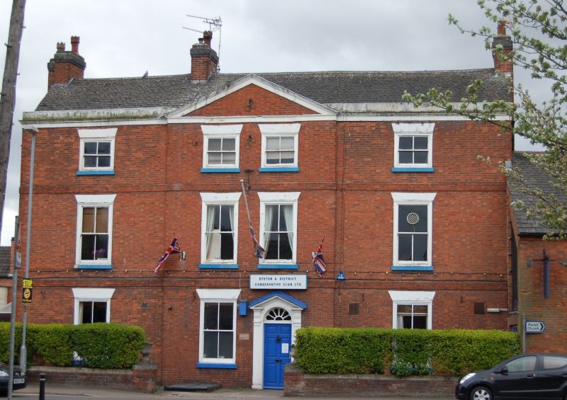
SYSTON
HIGH STREET (south side)
No. 59
GV
II
House, early C19. Brick with Swithland slate roof. A tall two storeys and four bays with central pedimented gable containing four-light sash window to left and a doorway to right; six-panelled door with radial fanlight beneath an open pediment supported on reeded shafts. All windows are four-light sashes with gauged brick heads. Wood parapet. Brick sill bands. Gable stacks.
Listing NGR: SK6253211783
External links are from the relevant listing authority and, where applicable, Wikidata. Wikidata IDs may be related buildings as well as this specific building. If you want to add or update a link, you will need to do so by editing the Wikidata entry.


Other nearby listed buildings
