Approximate Location Map
Large Map »
Latitude: 52.7198 / 52°43'11"N
Longitude: -0.7795 / 0°46'46"W
OS Eastings: 482537
OS Northings: 314266
OS Grid: SK825142
Mapcode National: GBR CQY.FRJ
Mapcode Global: WHFK8.0W3V
Plus Code: 9C4XP69C+W6
Entry Name: 28, Oakham Road
Listing Date: 21 February 1984
Grade: II
Source: Historic England
Source ID: 1177997
English Heritage Legacy ID: 186729
ID on this website: 101177997
Location: Whissendine, Rutland, LE15
County: Rutland
Civil Parish: Whissendine
Built-Up Area: Whissendine
Traditional County: Rutland
Lieutenancy Area (Ceremonial County): Rutland
Church of England Parish: Whissendine St Andrew
Church of England Diocese: Peterborough
Tagged with: Building
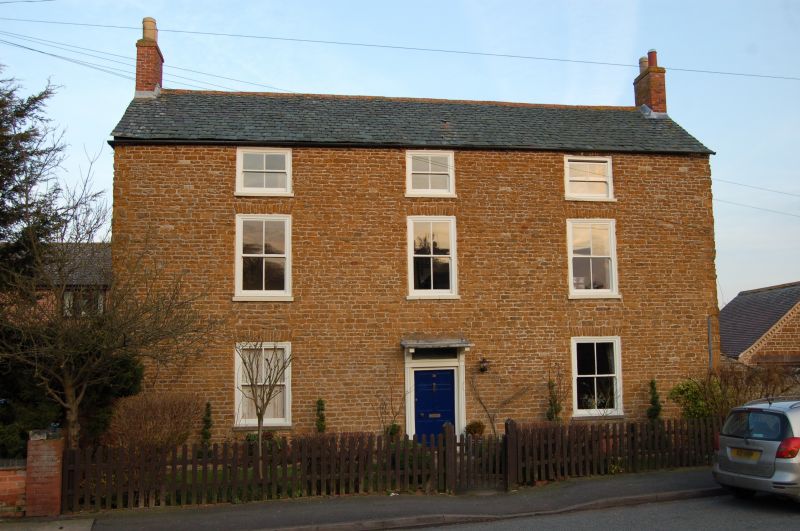
WHISSENDINE
SK 81 SW OAKHAM ROAD (East side)
5/159 No.28
II
House of c1800. Coursed rubble stone and Swithland slate roof with brick
end stacks. 3 storeys of 3 2/2 sash windows. Central moulded wooden doorcase
with flat bracketted canopy and 6-panelled door with overlight. 2 storey
wing to rear.
Listing NGR: SK8253714266
External links are from the relevant listing authority and, where applicable, Wikidata. Wikidata IDs may be related buildings as well as this specific building. If you want to add or update a link, you will need to do so by editing the Wikidata entry.


Other nearby listed buildings
