Latitude: 52.8736 / 52°52'24"N
Longitude: -3.0026 / 3°0'9"W
OS Eastings: 332615
OS Northings: 331148
OS Grid: SJ326311
Mapcode National: GBR 75.R34G
Mapcode Global: WH89X.V1CC
Plus Code: 9C4RVXFW+CX
Entry Name: Whittington Castle
Listing Date: 8 October 1959
Last Amended: 2 September 1987
Grade: I
Source: Historic England
Source ID: 1178307
English Heritage Legacy ID: 255836
ID on this website: 101178307
Location: Whittington, Shropshire, SY11
County: Shropshire
Civil Parish: Whittington
Built-Up Area: Whittington
Traditional County: Shropshire
Lieutenancy Area (Ceremonial County): Shropshire
Church of England Parish: Whittington St John the Baptist
Church of England Diocese: Lichfield
Tagged with: Castle
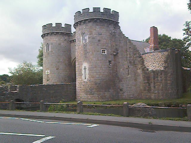
WHITTINGTON C.P. CASTLE STREET (west side) SJ 3231-3331 11/120 Whittington Castle (formerly listed as The 8.10.59 Castle) GV I Castle, remains of. Begun c.1221 by Fulke Fitz Warine on site of late C11 or C12 motte and bailey castle. Regularly coursed and dressed grey limestone blocks with ashlar dressings; towers of outer gatehouse now with slate roofs. Original castle of motte and bailey type with bailey to north-west, replaced by rectangular plan with projecting semi-circular towers to inner and outer baileys, protected by elaborate water defences. Principal survival is outer gatehouse: 2 D-shaped towers flanking broad pointed single-chamfered arch with roll moulding. 2 levels with plain corbel table and embattled parapet. Restored pointed windows with C19 cast-iron casements to upper level and cross- shaped arrow-loops to lower level; stepped plinth. Arch has double nail- studded plank doors with restored panelling to inner face; small armorial shield above looks C19. Projecting corbelled fireplaces to left and right in angle with curtain wall, which has cross-shaped arrow-loops plus 2 semi- circular bastions to right side. Gatehouse approached by short roughly coursed limestone rubble late medieval bridge with segmental pointed arch. Left return wall of left tower has 2-light trefoil-headed window with square label on upper level. Inner wall has segmental-headed chamfered doorway in angle with gateway. Right curtain wall has late C17 cottage, now offices, behind. Timber framed with narrow red brick infill, rendered to front and left gable end; slate roof. One storey and attic; apparently of 2 framed bays. Framing: square panels, 3 from chamfered plinth to wall-plate, much altered to front; collar and tie beam truss exposed to left gable end. 2 late C20 casements to ground floor and 3 contemporary raking eaves dormers. Entrance to right through late C20 panelled door under contemporary lean-to porch. Stepped external end stack to left has top rebuilt in late C19 yellow brick; similar red brick stack to back wall also with top rebuilt in C19 yellow brick. Extensive ruins of rectangular raised platform to south of moat to south of outer gatehouse. Facing largely robbed but rubble core survives. Semi- circular bastion at north-west angle has narrow C13 four-centred arch on first level to east side, probably originally approached by external steps; remains of mutilated window opening above and narrow arrow-loop to west. Remains of another small bastion behind, formerly forming part of gatehouse, and of larger bastions to north-east, south-east and south-west corners. Foundations of several buildings on platform uncovered by excavation, including those of central rectangular tower (possibly the keep) with a forebuilding to east and a circular tower. Several fireplaces and a well. Extensive earthworks in fields to south and west and probably also formerly to east, but now truncated in latter direction by road, include an oval-shaped flat-topped mound to west, which may be the original motte. Water played an important part in the castle's defences and the surrounding moats are best preserved to the north, south and east of the outer gatehouse. Much destruction occurred in the mid-to late C18, the eastern tower collapsing in 1760 with one of the northern towers and part of the west wall being demolished shortly afterwards to provide material for repairs to the Whittington-Halston road. Scheduled Ancient Monument (County No.17). Interior. Only partial inspection of outer gatehouse possible at time of resurvey (June 1986) and apparently much altered but likely to retain some features of interest. B.o.E. p. 317; V.C.H. Vol I (1908), p.401; William Cathrall, The History of Oswestry (1855), p.281. James Forde-Johnston, Great Medieval Castles of Britain (1979), pp.68-9.
Listing NGR: SJ3260931152
External links are from the relevant listing authority and, where applicable, Wikidata. Wikidata IDs may be related buildings as well as this specific building. If you want to add or update a link, you will need to do so by editing the Wikidata entry.


Other nearby listed buildings