Approximate Location Map
Large Map »
Latitude: 53.0123 / 53°0'44"N
Longitude: -0.9604 / 0°57'37"W
OS Eastings: 469847
OS Northings: 346613
OS Grid: SK698466
Mapcode National: GBR BKW.40V
Mapcode Global: WHFHT.6KY2
Plus Code: 9C5X226Q+WR
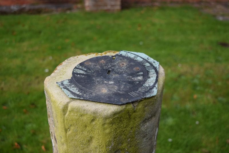
Entry Name: Sundial in Churchyard of Church of St Michael, 6 Metres South of the Nave
Listing Date: 13 March 1986
Grade: II
Source: Historic England
Source ID: 1178729
English Heritage Legacy ID: 242022
ID on this website: 101178729
Location: St Michael's Church, Hoveringham, Newark and Sherwood, Nottinghamshire, NG14
County: Nottinghamshire
District: Newark and Sherwood
Civil Parish: Hoveringham
Built-Up Area: Hoveringham
Traditional County: Nottinghamshire
Lieutenancy Area (Ceremonial County): Nottinghamshire
Church of England Parish: Hoveringham
Church of England Diocese: Southwell and Nottingham
Tagged with: Sundial
HOVERINGHAM GONALSTON LANE
SK 64 NE (south side)
4/70 Sundial in church-
yard of Church of
St. Michael, 6
metres south of
the nave
G.V. II
Sundial. Early C18. Ashlar, some lead. Ashlar base with
chamfered corners and broach spurs. Surmounted by a slim
octagonal shaft with broach stops at the base. The top has the
remains of a lead sundial.
Listing NGR: SK6984746613
External links are from the relevant listing authority and, where applicable, Wikidata. Wikidata IDs may be related buildings as well as this specific building. If you want to add or update a link, you will need to do so by editing the Wikidata entry.


Other nearby listed buildings
