Approximate Location Map
Large Map »
Latitude: 51.262 / 51°15'43"N
Longitude: -1.6087 / 1°36'31"W
OS Eastings: 427399
OS Northings: 151497
OS Grid: SU273514
Mapcode National: GBR 60H.VGF
Mapcode Global: VHC2J.2JDX
Plus Code: 9C3W796R+QG
Entry Name: Crawlboys Farmhouse
Listing Date: 27 May 1964
Grade: II
Source: Historic England
Source ID: 1181205
English Heritage Legacy ID: 312445
ID on this website: 101181205
Location: Wiltshire, SP11
County: Wiltshire
Civil Parish: Ludgershall
Traditional County: Wiltshire
Lieutenancy Area (Ceremonial County): Wiltshire
Tagged with: Farmhouse
LUGERSHALL CRAWLBOYS LANE
SU 25 SE
(north side)
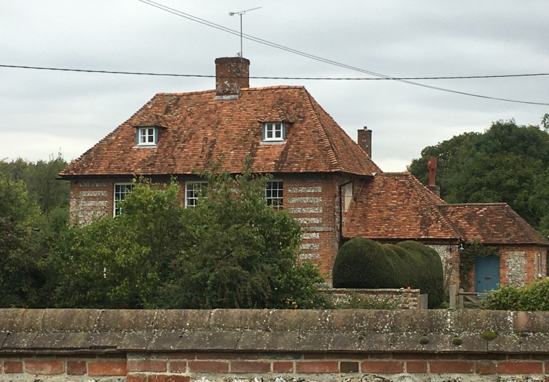
9/114 Crawlboys Farmhouse
27.5.64
II
Farmhouse. C18. Brick laced flint with tiled roof. Two storeys
and attic. Three bays x 2. Central entrance to hall. Four-light
leaded windows to ground floor, 16-paned sashes to first floor and
over door. Two hipped dormers. Central brick stack in hipped
roof.
Interior not seen. Said to have a small section of panelling.
Listing NGR: SU2739951497
External links are from the relevant listing authority and, where applicable, Wikidata. Wikidata IDs may be related buildings as well as this specific building. If you want to add or update a link, you will need to do so by editing the Wikidata entry.


Other nearby listed buildings
