Approximate Location Map
Large Map »
Latitude: 51.7804 / 51°46'49"N
Longitude: -1.1637 / 1°9'49"W
OS Eastings: 457787
OS Northings: 209414
OS Grid: SP577094
Mapcode National: GBR 8YW.6MF
Mapcode Global: VHCXP.SH4Z
Plus Code: 9C3WQRJP+5G
Entry Name: Farm building and attached walls, beside Menmarsh Road, from approximately 40 metres South to 65 metres East of Manor Farmhouse
Listing Date: 5 June 1985
Grade: II*
Source: Historic England
Source ID: 1182383
English Heritage Legacy ID: 246689
ID on this website: 101182383
Location: Stanton St John, South Oxfordshire, OX33
County: Oxfordshire
District: South Oxfordshire
Civil Parish: Stanton St. John
Built-Up Area: Stanton St John
Traditional County: Oxfordshire
Lieutenancy Area (Ceremonial County): Oxfordshire
Church of England Parish: Stanton St John
Church of England Diocese: Oxford
Tagged with: Agricultural structure Thatched building
This list entry was subject to a Minor Amendment on 28 April 2022 to remove superfluous amendment details and to reformat the text to current standards
SP50NE
5/169
STANTON ST. JOHN
POUND LANE (East side)
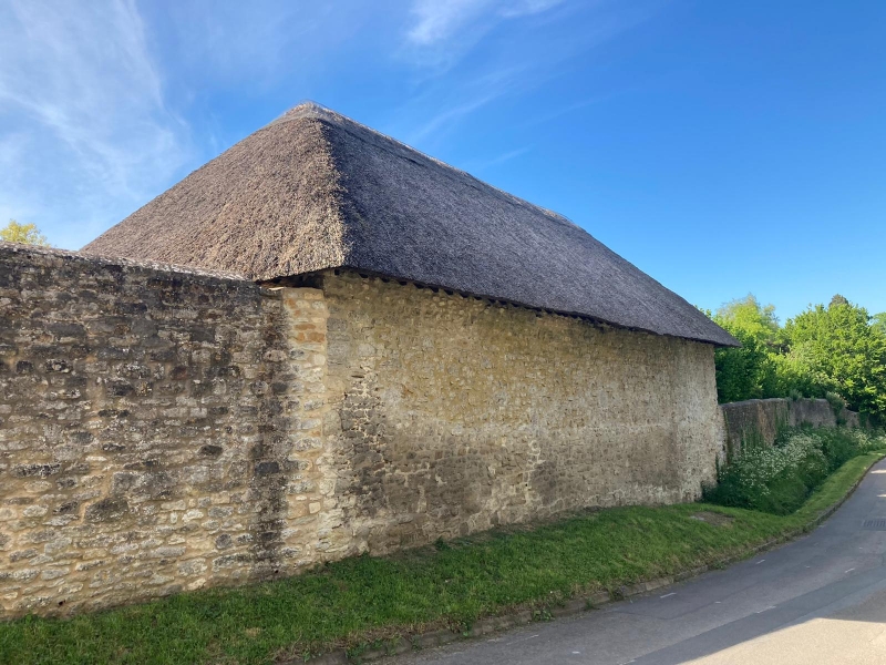
Farm building and attached walls, beside Menmarsh Road, from approx. 40m. S to 65m. E of Manor Farmhouse
GV
II*
Open shed/shelter and attached walls. C17/C18. Limestone rubble; thatched roof. Six-bay plan. Shelter has three rubble walls with a hipped roof.
Interior: five heavy cross beams are each carried by two posts, on tapering stone bases, and lodged on rear wall. Rough poles spanning between beams are overlaid with sticks and gorse, upon which the thatch is built up. Flanking high rubble walls are visually very important at the core of the village. The roof construction, which was probably originally thatched with gorse etc., is a rare survival of a primitive method.
Included for group value.
Listing NGR: SP5778609417
External links are from the relevant listing authority and, where applicable, Wikidata. Wikidata IDs may be related buildings as well as this specific building. If you want to add or update a link, you will need to do so by editing the Wikidata entry.


Other nearby listed buildings
