Approximate Location Map
Large Map »
Latitude: 51.1719 / 51°10'18"N
Longitude: -1.7825 / 1°46'56"W
OS Eastings: 415303
OS Northings: 141430
OS Grid: SU153414
Mapcode National: GBR 503.D5W
Mapcode Global: VHB5C.2S1Z
Plus Code: 9C3W56C9+Q2
Entry Name: Antrobus Arms
Listing Date: 10 October 1988
Grade: II
Source: Historic England
Source ID: 1182444
English Heritage Legacy ID: 321335
ID on this website: 101182444
Location: Amesbury, Wiltshire, SP4
County: Wiltshire
Civil Parish: Amesbury
Built-Up Area: Amesbury
Traditional County: Wiltshire
Lieutenancy Area (Ceremonial County): Wiltshire
Church of England Parish: Amesbury St Mary and St Melor
Church of England Diocese: Salisbury
Tagged with: Pub
AMESBURY CHURCH STREET
SU 1541
(south side)
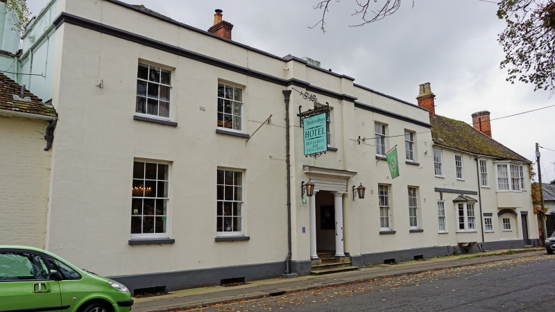
11/23 Antrobus Arms
GV II
Hotel. C18 and early C19. Painted and rendered brickwork, slate
roof. Two storeys and cellars. Main block of 5 bays rebuilt in
early C19. Central entrance bay defined by giant pilasters and
containing 2 Tuscan columns with pilasters in antis over 4 steps.
Twelve-paned sashes to flanking bays in deep reveals and concealed
boxes, 6-paned single hung sashes to first floor. Moulded cornice
and parapet concealing hipped roofs. Brick stacks. To right, C18
two-bay structure with tiled roof, with 12-paned sashes and raised
key blocks meeting plat band, and brick dentilled eaves. C19 added
oriel window to right bay. Further to right, 3 bays c1800, also of
painted brickwork with two C18 windows and large first floor oriel
window. Roof hipped. To left of main block, former stables,
probably C18 altered c1880, painted brick and tiled roof. Off-
centre garage door and 5 flush dormers with flat lead roofs. Roof
hipped.
Interior: Open porch behind portico has flagged stone floor and
moulded coffered ceiling. Wide glazed door to stair hall with open
well stair and iron balustrade.
(NMR 50088)
Listing NGR: SU1530341430
External links are from the relevant listing authority and, where applicable, Wikidata. Wikidata IDs may be related buildings as well as this specific building. If you want to add or update a link, you will need to do so by editing the Wikidata entry.


Other nearby listed buildings
